
PIN 743329 Elevation 4 m | Time zone IST (UTC+5:30) Telephone code 91 3218 | |
 | ||
Canning (also referred to as Port Canning) is headquarters of Canning subdivision and a town with a police station in South 24 Parganas district in the Indian state of West Bengal. Headquarters of two CD Blocks – Canning I and Canning II – of the subdivision are located in this town. Carrying the memory of an abandoned port, the town is dependent to some extent on the changing fortunes of the Matla River. It is a major centre for the supply of fish to Kolkata.
Contents
- Map of Canning West Bengal
- Etymology
- History
- Geography
- Education
- Fish centre
- Sunderbans Gateway
- Festivals and Fairs
- Transport
- References
Map of Canning, West Bengal
Etymology
The place is named after Lord Canning. He was Governor General of India from 1856 to 1858, and Governor General and Viceroy from 1858 to 1862.
History
H. E. A. Cotton writes, "The year 1864… It witnessed also the speculative mania over an unlucky scheme for the reclamation of the Sunderbands, of which nothing remains but the deserted wharves of Port Canning, but which resulted in ruin to many". The idea of developing a major port at Canning faded with the choking of the Matla river as a result of inadequate headwater supply.
Lord Canning wanted to build a port that would be an alternative to Kolkata and a rival to Singapore. What no one heeded were the warnings of a lowly shipping inspector Henry Piddington, who had lived in the Caribbean and knew all about hurricanes and storms. He wanted the mangroves to be left alone, as they were Bengal’s defensive barrier against nature’s fury and absorbed the initial onslaught of cyclonic winds, waves and tidal surges. They went on to build a grand Canning with a strand, hotels and homes, but in 1867, the Matla river surged its fury on the new port-town, reducing it to a "bleached skeleton". Two different building was made for the purpose of administration namely 'Golkuthi' and 'Hotelkuthi'. The first one was demolished completely and the hotelkuthi is still standing in a ruined form near Helicopter More, canning town.
In 1862, the Calcutta and South-eastern Railway opened a southward line from what was then known as Beliaghata station to Port Canning. In the same year, the East Bengal Railway had opened its line from Sealdah to Kushtia. It also opened its own southern line to Diamond Harbour. Calcutta and South-eastern Railway was taken over by the government in 1863. East Bengal Railway was taken over by the government in 1887. Services on the eastern side of Hooghly River was unified under Eastern Bengal State Railway and after further amalgamation in 1942, the Bengal Assam Railway.
Geography
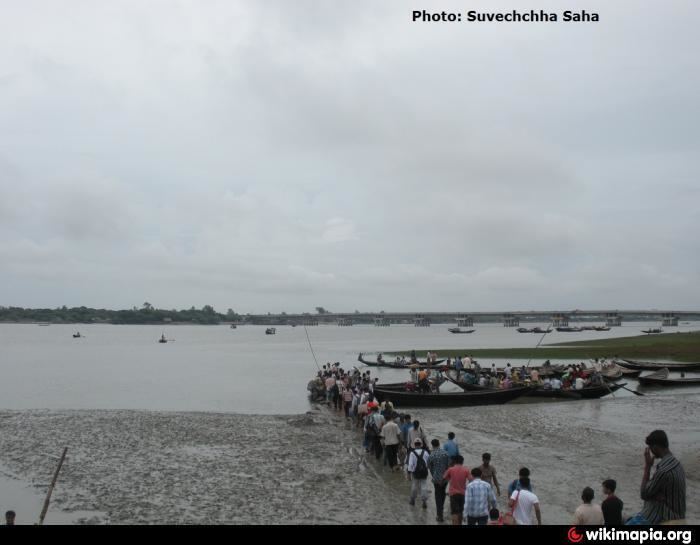
Canning is located at 22.32°N 88.67°E / 22.32; 88.67. It has an average elevation of 4 metres (13 feet). It is gateway to the Sundarbans. It is situated on the south bank of the Matla River. It is part of the Kolkata Suburban Railway system and is connected to Sealdah station and is also connected to Kolkata by road. One can cross the Matla River and then proceed to Basanti for a boat to the interior of the Sundarbans or hire a motor launch for travel to Sundarbans at Canning itself. The first watch tower at Sajnekhali is about 5 hours away.
The Matla River is so silted up that during the dry season, boats cannot come to the jetties. They have to be stationed 500 yards away. During the monsoons, the river becomes so turbulent that boats cannot ferry people across the river. The Sunderban Development Board has decided to build a bridge on the river Matla at an estimated cost of Rs. 290 million.
A 644 m road bridge across the Matla, was inaugurated by Buddhadeb Bhattachajee, Chief Minister, in January 2011. It links Canning with Basanti.
Education
Canning has three Higher Secondary School and they are Canning David Sassoon High School, Canning Dwarikanath Valika Vidlaya, Raibaghani High School and One Matrics level school St.Gabriel School. Bankim Sardar College which is affiliated to University of Calcutta is the only college in Canning Town. An ITI college is situated beside bankim sardar college.
Fish centre
Canning is a major market for supply of fish to Kolkata. The fishermen of the area bring their catch to the all-night fish market at Canning. Here the commission agents receive the fish and auction them. It is bought by the wholesalers and transported to Kolkata for sale to retailers, who sell it in the different markets. As greater part of Kolkata’s fish now come from South India and Madhya Pradesh, local wholesale trade at Canning and Bagnan has lost out in the competition.
Sunderbans' Gateway
Canning is the gateway to Sunderbans, the fascinating mangrove forest. Canning is connected to Kolkata by railway and roadways. Train can be availed from Sealdah South Section and fare is only Rs. 15. There are two roadways: one is via E.M. Bypass and Baruipur; the second is via Basanti Road. Numerous travel companies business in Canning and the cost vary depending on the service quality. Individual launch (boat) can be rented to visit Sunderbans. It takes around 4 hours to reach the Sunderbans.
Festivals and Fairs
Canning is a host of festivals and fairs. Most of them are timed during winter season. "Sunderban Mela" is the biggest fair of Canning and of entire South 24 Parganas. This fair is conducted by "Bandhumahal Club" of Canning from 3 to 12 January every year.
Next big festival is "Sunderban Utsav". This mainly conducted by the administration to bring up people of Sunderbans together and to interact.