
Country Area 61.91 sq mi | Founded 1807 Population 35,035 (2011) | |
 | ||
Unemployment rate 12.8% (Dec 2014) Mayor Hon. Edwin Garcia Feliciano (PNP) | ||
Map of Camuy, Puerto Rico
Camuy ([kaˈmwi]) is a municipality of Puerto Rico, bordering the Atlantic Ocean, north of Lares; east of Quebradillas; and west of Hatillo. Camuy is spread over 12 wards and Camuy Pueblo (The downtown area and the administrative center of the city). The town celebrated its 200th anniversary in 2007.
Contents
- Map of Camuy Puerto Rico
- Parque de las cavernas camuyhatillolares puerto rico north america
- Camuy pr
- History
- Geography
- Tourism
- Landmarks and places of interest
- Religion
- Sports
- Festivals and Events
- Agriculture
- Business
- Government
- Flag
- Coat of arms
- Education
- References
Camuy is part of the "Porta Atlántico" Tourist Area.
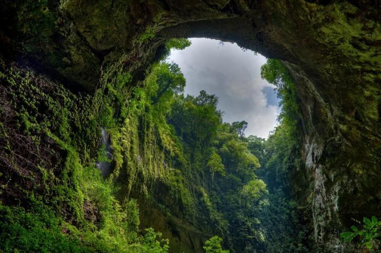
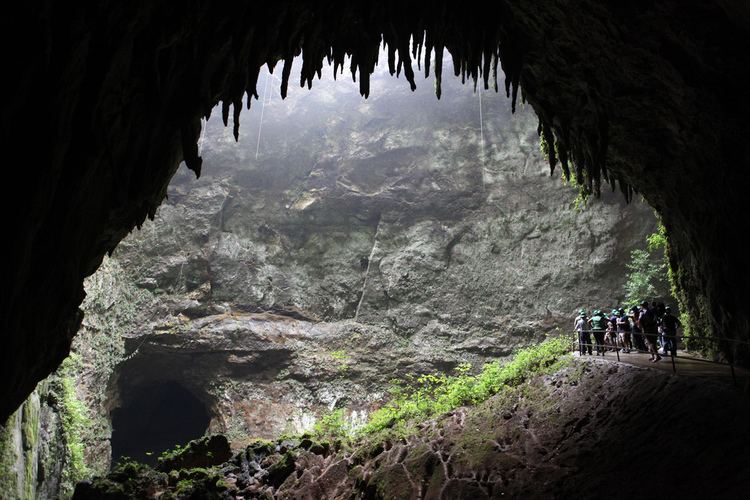
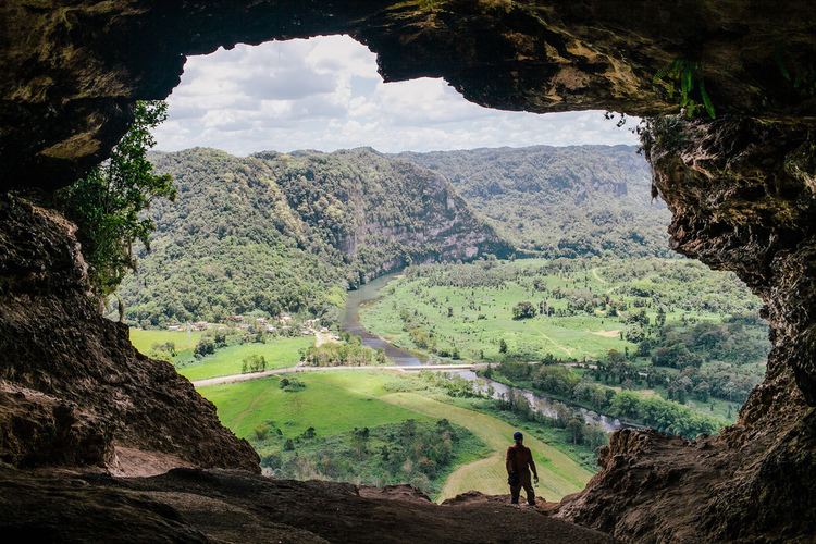
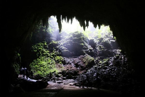
Parque de las cavernas camuyhatillolares puerto rico north america
Camuy pr
History
Camuy also known as "La ciudad romántica" was founded in 1807 Petronila Matos, and formerly part of Arecibo is located in the northwestern coastal region of Puerto Rico, less than 5 minutes west of Hatillo on PR-2 and PR-119. The name Camuy is known to be derived from the Taíno language, although a number of legends give differing explanations for the origin of the name. One such legend claims the name comes from the Taíno word for "sun", another claims derivation from camuy , Taíno for "beautiful scenery", and still another states that Camuy was the name of the Taíno chief Yumac with the letters in reverse order. The "sun" legend is reflected in the coat of arms for the municipality.
In its beginnings Camuy was integrated into the Partition of San Antonio de la Tuna. The "partitions" were great expanses of land that divided Puerto Rico. This region today is known as Isabela, Puerto Rico. At the time the partition covered the areas between Aguadilla and Arecibo, what is known today as the municipalities of Camuy, Hatillo, Quebradillas, Isabela, Utuado, and San Sebastián.
The population of Camuy was 35,159 at the 2010 census, and it has land area of 46.3 square miles (120 km2). The municipality is part of the San Juan-Caguas-Guaynabo metropolitan area and is a popular suburb. It was named in 2015 by the U.S. Conference of Mayors as one of the most livable cities in the United States.
Geography
Camuy belongs to the zone designated as the plateau of the northwest where the terrain is level and known as the Valley of Quebradillas. Towards the interior of the municipality, the topography becomes very irregular near Cibao. This strip of land, a zone of wooded hills and depressions, divides Camuy completely into two strips, north and south. The northern strip is known as Lomas de los Puertos.
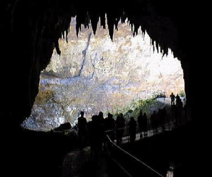
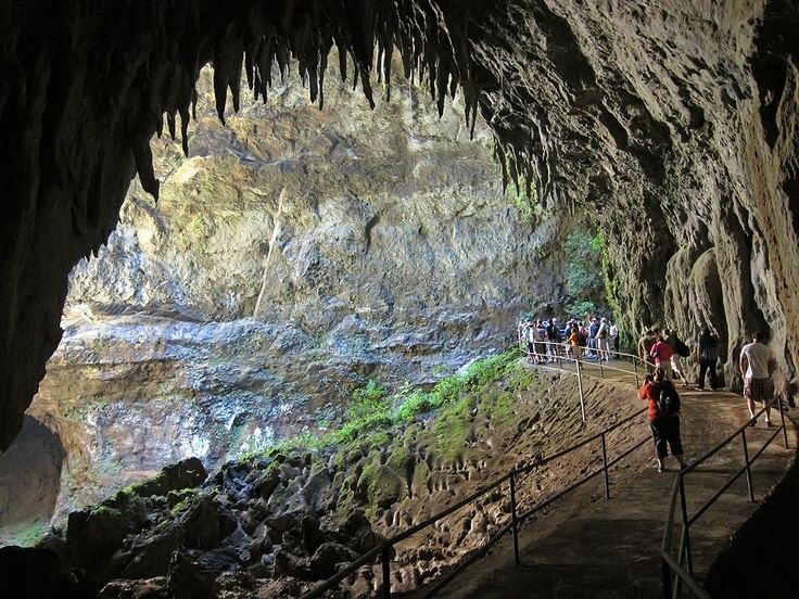
The Camuy River forms part of the hydrographic system with a length of 24 miles, which at one point becomes a narrow canyon that forms one of the most beautiful cave systems in the world: the Rio Camuy Caverns, first explored in 1958. The Camuy River along with the Caverns are the 3rd largest and longest underground system in the world and the river is one of the few remaining active underground rivers in the Americas, stretching for miles.
The Cibao River is also part of the system.
Tourism
Camuy is known for its Parque de las Cavernas del Río Camuy (Camuy River Cave Park), a large network of natural limestone caves and underground waterways shared with nearby municipalities of Hatillo and Lares. The cave system was first documented in the 1973 book Discovery At The Rio Camuy (ISBN 0-517-50594-0) by Russell and Jeanne Gurnee. The park built around the cave system features tours of some of the caves, and is one of the most popular natural attractions in Puerto Rico. The caverns were created by the Río Camuy (Camuy River), the third longest underground river in the world. In recognition of this, the Camuy coat of arms includes a symbol for the underground river.
Landmarks and places of interest
Religion
Just like the whole island, Camuy is first and foremost Catholic but there are other religions present in the town, including Protestant denominations such as the Pentecostals, Presbyterians, Methodists, and others. There are four Roman Catholic Parishes in Camuy: San Jose Parish named after the patron of the town and located in the town square, Saint Joseph The Miraculous Medal (also known as "El Calvario"), in the Piedra Gorda ward The Assumption of Mary, located at Barrio Quebrada Our Lady of Montserrate, located at Barrio Soller nearby Quebradillas Municipality. The other famous church is the Methodist church named "Iglesia de Piedra" (Church of Stone) because of its design. The whole church is made completely out of stone.
Sports
The town has many sports (Volleyball, Basketball, Martial Arts, Swimming etc.) but most notably are their baseball teams. Many of them are part of the little league and the intermediate system but at the top the two professional Class A and Double AA baseball teams called "Los Arenosos" (Referring to the abundance of sand from the coastline).
Festivals and Events
The patron saint of Camuy is San José. His day is celebrated on March 1. The patron saint festivities (Fiestas Patronales) are celebrated every year around the last 2 weeks of the month of March, the month of Saint Joseph. His official liturgical day is March 1.
Agriculture
Agriculture (sugarcane some time ago) Cattle and milk production.
Business
There's an active manufacturing industry in the city, including companies such as Alaska based Cazador Apparel, Seamless Textiles, Hanes, Best Quality Coop and Camuy Furniture Warehouse.
In terms of commercial development, several fast foods franchises, banks and stores can be found in Camuy. Two strip malls are also planned to be constructed in the city.
Tourism plays an important role in Camuy's economy due in part to the Rio Camuy Caves, and Camuy's public beaches.
Government
All municipalities in Puerto Rico are administered by a mayor, elected every four years. The current mayor of Camuy is Edwin García Feliciano, of the New Progressive Party (PNP). He was sworn in 2002.
The city belongs to the Puerto Rico Senatorial district III, which is represented by two Senators. In 2008, José Emilio González Velázquez and Angel Martínez Santiago were elected as District Senators.
Flag
The flag is green like the coat of arms. A white undulating band runs horizontally across and is interrupted in the middle by the figure of the Camuy sun, in this case represented by the colors yellow and black.
Coat of arms
The silver-waving stripe symbolizes the Camuy River (interrupted in the center because the river goes underground for part of its trajectory). The three tower crown distinguishes Camuy as a municipality.
Education
Camuy currently has: