
Country United States County Wayne Time zone EST (UTC-5) Elevation 285 m Population 1,820 (2013) Area code 765 | State Indiana FIPS code 18-09874 Zip code 47327 Local time Tuesday 1:46 AM | |
 | ||
Weather 15°C, Wind S at 24 km/h, 68% Humidity Area 2.642 km² (2.616 km² Land / 3 ha Water) | ||
Finished lincoln s funeral train mural in cambridge city indiana
Cambridge City is a town in Jackson Township, Wayne County, Indiana, United States. The population was 1,870 at the 2010 census.
Contents
- Finished lincoln s funeral train mural in cambridge city indiana
- Map of Cambridge City IN 47327 USA
- History
- Geography
- 2010 census
- 2000 census
- Culture
- Education
- Economy
- Notable people
- References
Map of Cambridge City, IN 47327, USA
History
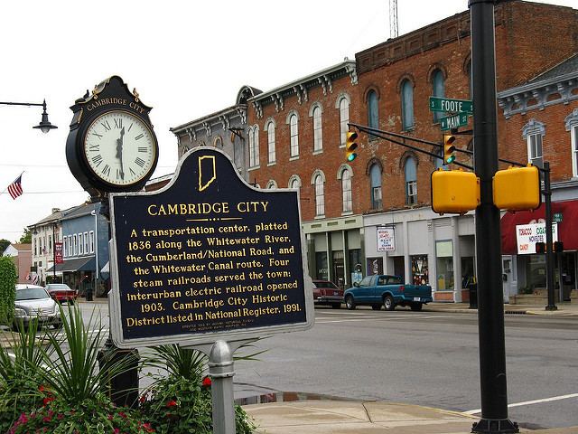
Cambridge City was laid out and platted in 1836. The community was named after the city of Cambridge, in England.
The Cambridge City post office has been in operation since 1835.
Cambridge City experienced growth when the Whitewater Canal was extended to that point in 1846.
Situated along the historic National Road (U.S. Route 40), Cambridge City is currently a prominent destination for antique seekers.
The Cambridge City Historic District, Conklin-Montgomery House, and Lackey-Overbeck House are listed on the National Register of Historic Places.
Geography
Cambridge City is located at 39°48′47″N 85°10′15″W (39.812996, -85.170812).
According to the 2010 census, Cambridge City has a total area of 1.02 square miles (2.64 km2), of which 1.01 square miles (2.62 km2) (or 99.02%) is land and 0.01 square miles (0.03 km2) (or 0.98%) is water.
2010 census
As of the census of 2010, there were 1,870 people, 785 households, and 514 families residing in the town. The population density was 1,851.5 inhabitants per square mile (714.9/km2). There were 893 housing units at an average density of 884.2 per square mile (341.4/km2). The racial makeup of the town was 98.5% White, 0.2% African American, 0.5% Native American, 0.3% Asian, 0.1% from other races, and 0.5% from two or more races. Hispanic or Latino of any race were 0.9% of the population.
There were 785 households of which 33.5% had children under the age of 18 living with them, 45.1% were married couples living together, 14.6% had a female householder with no husband present, 5.7% had a male householder with no wife present, and 34.5% were non-families. 29.2% of all households were made up of individuals and 12.6% had someone living alone who was 65 years of age or older. The average household size was 2.38 and the average family size was 2.90.
The median age in the town was 39.8 years. 24.5% of residents were under the age of 18; 7.6% were between the ages of 18 and 24; 24.8% were from 25 to 44; 26% were from 45 to 64; and 17% were 65 years of age or older. The gender makeup of the town was 48.8% male and 51.2% female.
2000 census
As of the census of 2000, there were 2,121 people, 904 households, and 602 families residing in the town. The population density was 2,030.6 people per square mile (787.4/km²). There were 956 housing units at an average density of 915.3 per square mile (354.9/km²). The racial makeup of the town was 99.34% White, 0.33% African American, 0.09% Asian, 0.05% Pacific Islander, 0.14% from other races, and 0.05% from two or more races. Hispanic or Latino of any race were 1.04% of the population.
There were 904 households out of which 29.0% had children under the age of 18 living with them, 49.2% were married couples living together, 13.1% had a female householder with no husband present, and 33.3% were non-families. 29.6% of all households were made up of individuals and 16.6% had someone living alone who was 65 years of age or older. The average household size was 2.35 and the average family size was 2.85.
In the town, the population was spread out with 23.8% under the age of 18, 9.4% from 18 to 24, 26.2% from 25 to 44, 21.5% from 45 to 64, and 19.1% who were 65 years of age or older. The median age was 38 years. For every 100 females there were 88.0 males. For every 100 females age 18 and over, there were 86.4 males.
The median income for a household in the town was $33,750, and the median income for a family was $41,731. Males had a median income of $35,602 versus $23,100 for females. The per capita income for the town was $17,691. About 6.9% of families and 8.6% of the population were below the poverty line, including 14.4% of those under age 18 and 7.0% of those age 65 or over.
Culture
The town celebrates its history and heritage during the second weekend in each September during the annual Canal Days festival, which commemorates the importance of the Whitewater Canal to the formation and growth of Cambridge City in the 19th century.
Education
Cambridge City has three schools: an elementary, middle, and high school that also serves the surrounding areas.
Economy
Just south of I-70, Cambridge City is home to the Indiana Gateway Industrial Park which is home to Taconic Biosciences, Dot Foods and Sugar Creek Packaging Co. (replacing Really Cool Foods which closed in December 2011).