
- elevation 5,807 ft (1,770 m) Basin area 1,808 km² Country United States of America | - elevation 4,800 ft (1,463 m) Mouth Big Wood River | |
 | ||
- location west of Hill City, Elmore County, Idaho - location Magic Reservoir, Camas/Blaine counties, Idaho | ||
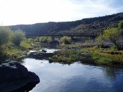
Camas Creek is a 64-mile (103 km) long tributary of the Big Wood River in the U.S. state of Idaho. Beginning at an elevation of 5,807 feet (1,770 m) west of Hill City in eastern Elmore County, it flows east into Camas County, where it is roughly paralleled by U.S. Route 20. About 10 miles (16 km) east of Fairfield, it forms the Camas-Blaine county line and continues east to its mouth at Magic Reservoir, at an elevation of 4,800 feet (1,463 m). Camas Creek has a 698-square-mile (1,810 km2) watershed.
Map of Camas Creek, Idaho, USA
References
Camas Creek (Big Wood River) Wikipedia(Text) CC BY-SA