
Local authority Land area 80 ha (0.31 sq mi) Southwest Burnside, Otago | Date established 1900s Population 1583 (2013 NZ Census) Southeast Corstorphine, New Zealand | |
 | ||
Calton Hill is an elevated southern residential suburb of the City of Dunedin in New Zealand's South Island. The suburb is named after Calton Hill in Edinburgh, Scotland, and some of its street names carry similar etymological roots. It covers an area of approximately 80 hectares (200 acres) and has 627 households comprising 1583 residents. It is one of the poorest suburb in Dunedin with high levels of deprivation.
Contents
- Map of Calton Hill Dunedin New Zealand
- Geography
- Surrounding areas
- History
- Pre colonial history
- European colonisation
- The twentieth century
- Demographics
- Governance
- References
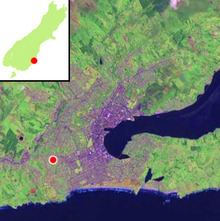
Map of Calton Hill, Dunedin, New Zealand
The suburb was established in the 1900s, as part of the second wave of suburban development in Dunedin. The parent suburb is Caversham, one of Dunedin's (and New Zealand's) oldest suburbs, established two generations prior as part of the first wave of settlement of the area. During the first wave of settlement before Calton Hill was established it unclear what modern day Calton Hill was called; possibilities include Caversham Hills or more colloquially John Sidey's farm.
Calton Hill is the geographical area bounded by the Dunedin Southern Motorway to the north and the Caversham Valley Forest Reserve beyond; farmland in the south and west that borders Concord and the Burnside industrial area; and an arbitrary eastern border of Corstorphine Road, Sidey Street, Cole Street and South Road (where it terminates near the Dunedin Southern Motorway). The South Island Main Trunk railway and the motorway (part of State Highway 1) further distinguish its northern border.
For many of those on the northern and eastern slopes, Calton Hill has views to Mt Cargill (Kapukataumahaka) and Flagstaff (Te Whanaupaki) in the north and the Pacific Ocean in the south-east. To the east, Calton Hill looks over the central plains of Dunedin city with Signal Hill (Te Pahuri o te Rangipohika), the Otago Harbour and Otago Peninsula in the distance. For those on the western slopes, the Kaikorai Valley and Green Island are in immediate view with Saddle Hill and the Taieri Plains beyond.
Geography
The heart of Dunedin City is a central plain surrounded by hills, the remnants of a long-extinct volcano. Calton Hill lies around 6 km to the southwest of the city centre (The Octagon); line of sight with Calton Hill from the Octagon is obscured by a large hill spur heading east from the main ridge line that forms the western edge of central Dunedin. Looking up and to the west from the southern end of Dunedin's central plain, Calton Hill is the most northern prominence.
Calton Hill has a crowning northerly ridge with two high points, bookended by the upper section of Corstorphine Valley in the south and Lookout Point saddle in the north. Two north-northeast running spurs and slopes drop down from this ridge into the upper reaches of the Caversham Valley. Between these two spurs lies a north-facing bowl,. To the southwest, the hill's slopes meet farmland bordering Burnside and Concord. The majority of the suburb is between 60 and 130 m above sea level.
Surrounding areas
Calton Hill shares its immediate borders with suburbs of Corstorphine, Concord and Burnside (separated by farmland), and Caversham and Maryhill (separated by partially forested, partially populated south facing hill slopes of the Caversham Valley). Calton Hill also shares borders with the small suburb of Lookout Point to the north. The 3.4-hectare (8.4-acre) Caversham Forest Reserve is located as part of this area. Purchased by the Dunedin City Council in 1994 with the assistance of the Royal Forest and Bird Protection Society, it is home to various native bird and invertebrate species, including one species of velvet worm believed to be endemic to the Dunedin area.
Residential areas in New Zealand are often not clearly defined, and suburban boundaries often overlap and change depending on subjective understandings. It is unclear whether residents within the geographical area of Calton Hill identify with Calton Hill as the community they belong to, or Lookout Point, Caversham, or Corstophine.
History
Prior to the arrival of humans to New Zealand, the area of Calton Hill was likely clothed in a dense and highly diverse mixed podocarp/broadleaf forest. Soil consisted largely of windblown loess over a weathered bedrock of sandstone covered by the Dunedin Volcanic Complex metamorphic processes.
Pre-colonial history
Approximately 800 years ago, Māori arrived on these islands. During the pre-colonial period mana whenua (territorial rights) over the Calton Hill area were held by three indigenous iwi (tribes), though there is no known archaeological evidence that shows direct residential occupation of Calton Hill itself. By the 19th century, two of these three iwi (Kāti Mamoe and Waitaha) had largely been subsumed by the largest, Kāi Tahu. The Calton Hill/Caversham Valley area was likely used as a thoroughfare south alongside coastal transportation provided by waka hourua (double hulled sailing canoes). Various areas may have been sites for nohoanga (temporary food gathering camps), gathering potable water, mahinga kai (food gathering area) for aruhe (bracken root) and ti kouka (Cabbage Tree), and for collecting other useful materials and resources.
There are only two surviving place names of the area to suggest it was an important area to the Māori. The bordering saddle of Lookout Point was named Koranga-a-runga-te-raki after Kāti Mamoe late 18th century chief Te Raki Ihia, who was largely responsible for joining the Kai Tahu and Kãti Mamoe iwi together. He was buried here so that "his spirit might see hence his old haunts to the southward." The ridge-line which runs from St Clair Beach to the Lookout Point saddle is known as Whakaherekau (possibly meaning "to make a conciliatory present"). This latter name may have been used by tangata whenua to name the entire area.
European colonisation
At the time of the Treaty of Waitangi being negotiated and signed in January and February 1840, Calton Hill was probably by then a mosaic of tussock grassland and bracken shrubland with pockets of podocarp and broadleaf forest in steep gullies. Botanical records indicate the Calton Hill area that once was covered in dense podocarp, broadleaf forest had been displaced by human-lit fires. In the years prior to this it is unlikely the area would have been used by the small number of Europeans who inhabited the country.
From 1844 to 1863 Ngāi Tahu sold their lands to the Crown in a series of nine purchases. Calton Hill was 200 acres of a total of 400,000 acres (160,000 ha) that made up the Otago Purchase, completed on 31 July 1844. The Crown reimbursed just £2,400 to local chiefs. In 1848, the first colonist ships arrived in the Dunedin area.
In 1855 John Sidey purchased a large area of land stretching from the Caversham Hills (modern day Corstophine, Calton Hill) to Mount Grand/ Kaikorai Hill 4km away above Kaikorai Valley. With the exception of steep, inaccessible gully areas, most other area would have been cleared, sown with exotic grass species, and fenced for cattle farming. A small number trees may have been harvested for building products and firewood. During this time, there was a non-shingled road that skirted the northern edge of Calton Hill and up the Caversham Valley and over the Lookout Point saddle.
In 1861, gold was discovered in Central Otago. Whilst hundreds of kilometres away, the northern edge of modern-day Calton Hill was a short stretch of the primary goldrush highway. Thousands of people began trekking past with their swags following the Caversham Valley as the only road south to the diggings of the Central Otago Gold Rush. John Sidey would supply the miners with meat from his farm and other carted supplies.
Now, the area has two railway lines that have been tunnelled through the sandstone beneath. One is no longer open for transport; the other remains part of the main south trunk line. The first tunnel was established in December 1873. The second completed in 1910, the tunnels provided a transport link to and from the city and other urban areas of Dunedin until the 1960s. The Caversham railway station, only 10 to 15 minutes walk from any part of Calton Hill, was the nearest station. In addition to the railway line, between 1880 and 1940, residents could also use the Dunedin cable tramway system. The nearest station was also at Caversham.
The twentieth century
The first published mention of the existence of Calton Hill is from 1907. The farmland was surveyed for the establishment of roads, related infrastructure and residential sections. The "Township of Calton Hill" was formally gazetted by the City of Dunedin 19 November 1907 with advertisements appearing in newspapers for "choice sections, view and sun, low prices". Bare land remained for much of the sections until the first houses were built immediately prior to World War I, with remaining farmland tendered for grazing.
A concentrated phase of building occurred during the 1950s and 1960s, completed through the Government's state housing scheme established 15–20 years previous. Mass public transport was being replaced by mass private transport; garages were retrofitted on older houses to store cars and the suburb's population increased. Riselaw Road School was established in 1953 along with a community hall, play centre, and other facilities for children and families on the adjacent Riselaw Road site.
Demographics
As at the 2013 NZ census, there were 1583 residents living in the suburb of Calton Hill, with 627 households located on the area's 16 streets, roads and avenues. The median age was 30.5 years of age and the median income was $23,800 per annum. A high-proportion of Calton Hill residents are of low socio-economic status compared to those of other suburbs of Dunedin, with a significant proportion of the 627 households being in the Riselaw Road state-owned housing areas built during the 1950s and 1960s.
Originally Riselaw Road School was a hub for the community. Now, the local primary school has been amalgamated and renamed as Carisbrook School Heights Site. It has two classes on its roll. Adjacent to the school is the Riselaw Road Playcentre. Other community facilities include two public bus services, Calton Hill Community Hall, the Dunedin Public Library Book bus (which visits the suburb once a week), two children's playground areas, sports fields alongside the school, and other public infrastructure typical of a New Zealand suburb (street lights, curb and channel drainage etc.). Potential public recreation areas lie to the north with a forest reserve, and to the south with under utilised sports grounds and bordering farmland. The nearest secondary schools are Queen's High School and King's High School located in Forbury, 2–3 km to the south on the boundary between South Dunedin and St Kilda. The closest commercial/retail area is in South Road, Caversham. Residents are serviced by two retail food businesses on opposite ends of Riselaw Road. There are a few home-based businesses, but the area is primarily residential.
Governance
Calton Hill falls within Dunedin City and as such is under the governance of Dunedin City Council and the Otago Regional Council. The area is not represented by any of Dunedin's six community boards, but is solely part of the greater area of the City of Dunedin. Health issues are under the management of the Southern District Health Board. Indigenous governance of Calton Hill falls within the takiwa of the Otakou Runaka, one of the 18 hapu of the Kai Tahu iwi. Since 2009, Tahu Potiki has been the appointed representative for the Otakou Runaka.
Nationally, Calton Hill falls within the Dunedin South electorate. As of 2014, the MP for Dunedin South is Clare Curran (Labour). Calton Hill is also part of Te Tai Tonga electorate, one of the country's seven Māori seats. As of 2014, the MP for Te Tai Tonga is Rino Tirikatene.