
Easiest route Hike | Elevation 669 m | |
 | ||
Similar Bláhnjúkur, Ingólfsfjall, Tindfjallajökull, Ármannsfell, Rauðhólar | ||
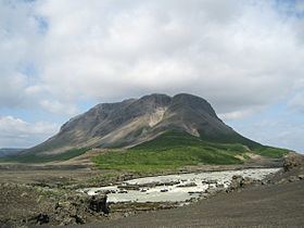
Búrfell (Þjórsárdal) is a 480 m (1,570 ft) basalt tuya located in Iceland. It is situated in the south of the country along the western boundary of the Þjórsárdalur valley.
Contents
Map of B%C3%BArfell, Iceland
Name
There is a lot of different mountains in Iceland by the name of Búrfell, f. ex. Búrfell (Grímsnes), Búrfell (Þingvellir) and Búrfell (Mývatn).
The Icelandic word búr means cage or pantry in English.
Búrfellsvirkjun
At the foot of the mountain as well as in the mountain itself, there is Búrfellsvirkjun, one of the biggest hydroelectric power stations of Iceland. It started working in 1972 after being erected mainly to produce energy for the aluminium factory (Alcan) in Straumsvík in the vicinity of Reykjavík. It is producing at the moment 270MW.
A lot of the tubes as well as the main power station are lying in tunnels within the mountain.
The Viking farm museum of Þjóðveldisbær is also situated at the foot of this mountain.