
Width 37 km (23 mi) Elevation 153 m | Length 46 km (28.6 mi) Highest elevation 153 m (502 ft) Qikiqtaaluk Region — Area 1,150 km² | |
 | ||
Island groups Canadian Arctic Archipelago, Queen Elizabeth Islands | ||
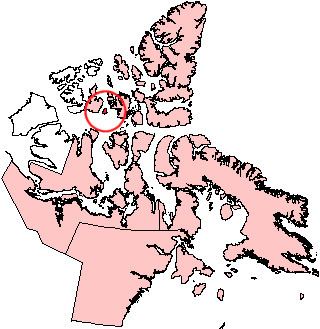
Byam Martin Island (BEI-uhm) is one of the Canadian arctic islands located on the northern side of the Viscount Melville Sound in the territory of Nunavut. It is separated from the eastern coast of Melville Island, 27 km (17 mi) to the west, by the Byam Martin Channel; and from Bathurst Island, 35 km (22 mi) to the northeast, by the Austin Channel.
Map of Byam Martin Island, Baffin, Unorganized, NU, Canada
Byam Martin Island is 46 km (29 mi) long, 37 km (23 mi) wide, and measures 1,150 km2 (440 sq mi) in area.
The island was named after Sir Thomas Byam Martin by Sir William Edward Parry in August 1819 during his first expedition to discover the Northwest Passage.
References
Byam Martin Island Wikipedia(Text) CC BY-SA