
Location Ducktown, Tennessee Active 60 Built 1899 Address Copperhill, TN 37317, USA Added to NRHP 1983 | Products Copper Closed 1959 NRHP Reference # 83003059 Opened 1899 | |
 | ||
Similar Ducktown Basin Museum, Blue Ridge Mountains, Ocoee Whitewater Center, Blue Ridge Scenic Railway, Big Frog Mountain | ||
The Burra Burra Mine is a copper mine located in Ducktown, Tennessee, in the southeastern United States. Named for the famous mine in Australia, the Burra Burra Mine extracted over 15 million tons (14 million metric tons) of copper ore during its 60 years of operation between 1899 and 1959. The mine's remaining structures are listed on the National Register of Historic Places as part of the Burra Burra Mine Historic District. The site is also home to the Ducktown Basin Museum, and the museum and mine are a Tennessee State Historic Site operated in partnership with the Tennessee Historical Commission.
Contents
The Burra Burra Mine was one of a number of mining operations in the Copper Basin from 1850 to 1987. While these operations produced substantial amounts of copper and other products, tree-harvesting and pollution from the mines and smelters left more than 32,000 acres (130 km2) of the basin virtually devoid of life, though the area has begun to recover due to re-greening efforts.
Geographical settingEdit
The Burra Burra Mine is located near the center of the Copper (or Ducktown) Basin, a broad valley in the southern Appalachian Mountains near the common borders of Tennessee, North Carolina, and Georgia. The basin—actually an area of low hills rather than a true basin— is surrounded on all sides by mountains, including Pack Mountain to the east, Stansbury Mountain to the north, Little Frog Mountain to the northwest, and Big Frog Mountain to the southwest, some more than 4,000 feet (1,200 m) high. A series of hills rise above the basin to the south.
The Ocoee River flows through the southwestern section of the Copper Basin, entering from Georgia (where it is known as the Toccoa) and exiting via a scenic gorge between Big Frog Mountain and Little Frog Mountain to the west. The river's Copper Basin segment is located at just over 35 miles (56 km) upstream from the river's mouth along the Hiwassee River near Benton, Tennessee. The Tennessee Valley Authority's Ocoee Dam Number 3 has created a reservoir that extends into the Copper Basin segment.
Ducktown, the location of the Burra Burra Mine, is in the center of the Copper Basin near the juncture of Tennessee State Route 68 and U.S. Route 64. Other communities located in or associated with the basin include Copperhill, near the Tennessee-Georgia border, Postelle in the northwest section of the basin, Isabella in the eastern portion, and Harbuck, Turtletown, and Farner just north of the basin. The Copper Basin is located almost entirely within Polk County, Tennessee, although parts of it extend into Fannin County, Georgia.
The mine is at 35°02′07″N 084°22′46″W, at an altitude of 1798 feet (548 m) above mean sea level.
HistoryEdit
The Copper Basin was part of Cherokee lands until 1836, when the Cherokee relinquished control of the basin to the U.S. government. The basin became part of the Ocoee District, which mostly consisted of what is now Polk County. While most Cherokees in the area were forced out as part of the Indian Removal of 1838, some managed to avoid detection and would later aide in road construction and mining operations.
Copper was first discovered in the Copper Basin in 1843 on a hill immediately southwest of what would eventually become the Burra Burra Mine (a reconstructed boiler chimney and Tennessee Historical Commission marker now mark the site along TN-68). This discovery sparked interest among regional entrepreneurs and opportunists, although the lack of major roads in and out of the basin complicated early mining operations. The Hiwassee Mine opened in 1850 near the site of the ore discovery at the center of the basin. Three years later, a road (now US-64) was constructed through the Ocoee Gorge, connecting the Copper Basin with Cleveland, Tennessee to the west. A total of nine separate ore deposits were discovered and worked within the southeast corner of Polk County, Tennessee. In 1860, several small-scale mining operations in the basin were consolidated to form the Burra Burra Copper Company, which was placed under the direction of mining engineer Julius Raht (1826–1879). The American Civil War (1861–1865) halted mining operations in the basin, although the industry briefly recovered after the war due in large part to Raht's efforts. By the late 1870s, however, Burra Burra and the basin's other mining operations— lacking a cost-effective way of transporting the ore out of the basin— were forced out of business.
The Burra Burra MineEdit
In the early 1890s, the Marietta & North Georgia Railroad and the Knoxville Southern Railroad built a rail line connecting the Copper Basin to Knoxville to the north and Marietta to the south, and mining operations resumed. In 1899, the Tennessee Copper Company, which had bought most of the mining operations in the Copper Basin, constructed a smelter at Copperhill and began work on the Burra Burra Mine at Ducktown. The company's open roast smelting method released large amounts of sulfur dioxide into the air, killing off all vegetation in the central basin. After being sued by local farmers and the state of Georgia over damage caused by the pollution, the Tennessee Copper Company began to recapture the sulfur dioxide. They converted the gas into sulfuric acid, which they successfully marketed.
The Tennessee Copper Company eventually merged with the Ducktown Sulfur, Copper, and Iron Company, and the merged company began to diversify. Along with copper and sulfuric acid, the company built a flotation plant to produce copper sulfate in the 1920s. Iron and zinc concentrates were also produced. By the time the Burra Burra Mine closed in 1958, its vertical shaft was over 2,400 feet (730 m) deep, making it one of the deepest vertical shafts in the North America. After the mine's closure, operations continued at other deposits within the Basin.
The Burra Burra Mine todayEdit
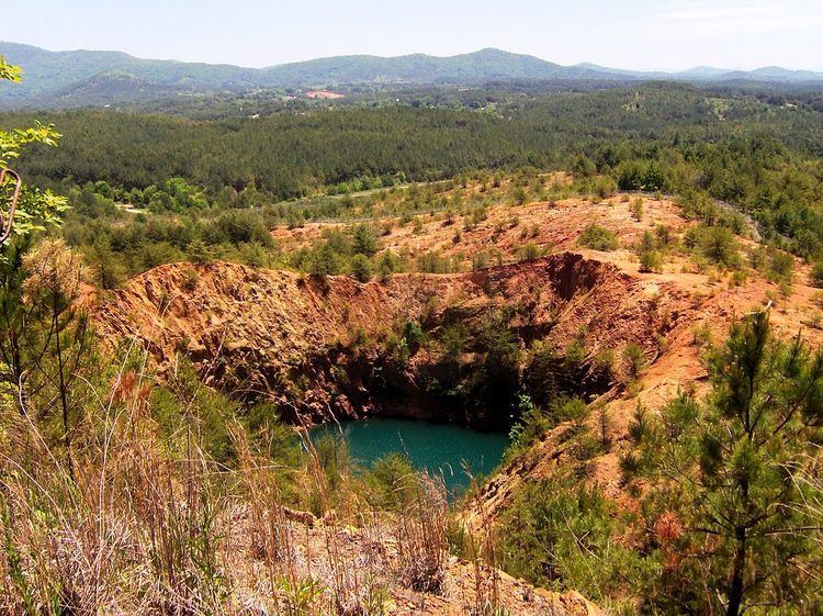
Mining ceased in the Copper Basin in 1987 when the Tennessee Chemical Company (Tennessee Copper's successor) filed for bankruptcy and sold off its holdings. As part of re-greening efforts, 16 million trees have been planted and the basin has been seeded with acid-tolerant grass. The Burra Burra Mine was part of a 300-acre (1.2 km2) stretch of land near the center of the basin selected to be exempted from the reclamation efforts to serve as a reminder of how the entire central basin once appeared. The Ducktown Museum and Burra Burra Mine were purchased by the state of Tennessee in 1988. The museum's establishment and assembly was due in large part to the basin's residents, many of whom remain fiercely loyal to the mining industry.
Ten of the mine's structures remain, including its hoist house, boiler building, powder house, and machine shops. The old engineers' office building now houses the Ducktown Basin Museum. Various machine parts, tools, and other artifacts used in the basin's mining operations are displayed on the museum's grounds. The museum's parking lot overlooks a massive sinkhole (now filled with water) created when part of the Burra Burra Mine collapsed.