
Population 11,630 (2011 census) Civil parish Burnham Area 19.84 km² Dialling code 01628 District South Bucks | OS grid reference SU9282 Sovereign state United Kingdom Local time Tuesday 6:53 AM | |
 | ||
Weather 4°C, Wind W at 11 km/h, 90% Humidity | ||
Burnham is a village and civil parish that lies north of the River Thames in the South Bucks District of Buckinghamshire, on the boundary with Berkshire, between the towns of Maidenhead and Slough. It is served by Burnham railway station in the west of Slough on the main line between London Paddington and Reading. The M4 motorway passes through the south of the parish.
Contents
Map of Burnham, Slough, UK
The toponym is derived from the Old English for "homestead on a stream". It was first recorded in the Domesday Book of 1086 as Burneham, when the manor was held by Walter FitzOther.
Burnham was once a very important village. The road from London to Bath (now the A4) passed through the extensive parish of Burnham and as a result, in 1271, it received a Royal charter to hold a market and an annual fair. However, when the bridge crossing the Thames in Maidenhead opened the road was diverted away from Burnham, which fell into relative decay. The market was then transferred to Maidenhead.
Today the village is mostly contiguous with Slough and green-buffered within its own areas. At the 2011 census the civil parish had a population of 11,630 and Burnham is the traditional village nucleus.
In 1265 a Benedictine abbey was founded near the village by Richard, King of the Romans. This was, however, disbanded by King Henry VIII in the Dissolution of the Monasteries. Since 1916, a contemplative order of Church of England Augustinian nuns has been based in the restored remains of the original abbey.
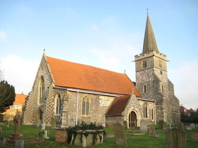
The Church of England parish church of Saint Peter dates in part from the 12th century but has been substantially expanded, refurbished and altered, with major restorations in 1863–64 and 1891 and the construction of the Cornerstone Centre in 1986.
Burnham Beeches is an area of 540 acres (220 ha) of protected ancient woodland, and is just north of the village. Dorneywood is in the parish.
Hamlets
The parish of Burnham included a number of communities: in the 18th century the liberties assessed for the poor rate were Burnham Town, East Burnham, Boveney, Britwell, Cippenham and Wood. Boveney became a separate civil parish in 1866 Cippenham was transferred to Slough in 1930, and therefore became part of Berkshire in 1974. Britwell was transferred to the borough of Slough and to Berkshire in 1974.
The current civil parish now includes Lent Rise, Rose Hill, East Burnham, Hitcham, Littleworth and Littleworth Common.
Schools
Burnham Grammar School and The E-ACT Burnham Park Academy provide secondary education to the children of Burnham and the surrounding area. Many students, however, commute to the nearby secondary schools in Slough. Priory School is the largest primary school in the area and provides primary education for many of the local children, although the smaller "Our Lady of Peace" Roman Catholic primary school is next to Priory School.
Owing to its proximity to Pinewood Film & TV Studios, Burnham and its surrounding areas (in particular Burnham Beeches) feature in films, notably main scenes in Carry On films and for the 1991 film Robin Hood: Prince of Thieves.
Amenities
There are four pubs on Burnham's High Street, with two more on the adjacent Church Street and Britwell Road.
Burnham Football Club is a Non-League football team that plays at The Gore.