
- elevation 4,278 ft (1,304 m) - average 40.4 cu ft/s (1.1 m/s) Basin area 1,557 km² Basin area 1,557 km² Country United States of America | - elevation 2,244 ft (684 m) Length 99.8 km Discharge 1.144 m³/s Mouth Malheur River | |
 | ||
- location Blue Mountains, Malheur County, Oregon - location near Vale, Malheur County, Oregon - max 8,980 cu ft/s (254.3 m/s) (February 24, 1957) | ||
Bully Creek is a 62-mile (100 km) long tributary of the Malheur River, located in the U.S. state of Oregon. It drains 601 square miles (1,557 km2) of Malheur County. Arising in the Blue Mountains, it flows generally southeast to its confluence with the Malheur River near Vale.
Contents
Map of Bully Creek, Oregon, USA
CourseEdit
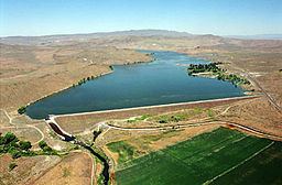
Bully Creek's headwaters are located near Sheep Rock in the southern edge of the Blue Mountains, southwest of Ironside. It flows east, receiving Indian and Cottonwood creeks on the right, and Clover Creek on the left. Traveling through the community of Westfall, the creek turns northeast. It is impounded by the 161-foot (49 m) tall Bully Creek Dam at river mile (RM) 8 or river kilometer (RK) 13, forming Bully Creek Reservoir. From the reservoir, the creek flows southeast until it reaches Highway 20. It parallels the highway and the Malheur River for several miles, passing through the outskirts of Vale. Bully Creek flows into the Malheur approximately 20 miles (32 km) above its confluence with the Snake River, which in turn flows into the Columbia River, and ultimately the Pacific Ocean.
WatershedEdit
Bully Creek drains 601 square miles (1,557 km2) of eastern Oregon. Wedged between the Northern Basin and Range and the Blue Mountains ecoregions, the watershed experiences an arid climate. Precipitation ranges from 9 to 23 inches (229 to 584 mm), with an average of 12 inches (305 mm). The highest elevation in the watershed is 6,447 feet (1,965 m) at Juniper Mountain, while the lowest is 2,244 feet (684 m) at the creek's mouth.
Flora and faunaEdit
Two hundred and five species of vertebrates have been identified within the Bully Creek watershed. Large mammals such as Rocky Mountain elk and mule deer, bobcats, beavers, otters, and raccoons inhabit the region. Twenty one species of fish have been spotted, but there are no anadromous species. The threatened bald eagle lives in the watershed during the winter.
The Bully Creek watershed is vegetated primarily by Sagebrush, although Quaking Aspen, Water Birch, and Cottonwood grow in riparian zones. Several noxious weeds have been identified, including Russian Knapweed and White Top.
HistoryEdit
The first humans arrived in the Bully Creek watershed about 13,000 years ago. The Northern Paiute tribe of Native Americans migrated to the region approximately 1,000 years ago. Whites first arrived in 1811 when fur traders from the Pacific Fur Company passed through. The Oregon Trail passed through the area in the 1840s, 50s, and 60s.
Melting snow and heavy rain caused an irrigation dam to fail on Bully Creek 19 miles (31 km) west of Vale on February 5, 1925. Flood waters surged down the creek, submerging Vale in 3 feet (1 m) of water, producing widespread damage. A railroad bridge and parts of Highway 20 were washed out, and many cattle and properties were destroyed. Overall, the flood caused over $500,000 in damage. Bully Creek Dam was constructed in 1963, used primarily for flood control.