
NRHP Reference # 87001232 Added to NRHP 30 July 1987 | Area 9.7 ha | |
 | ||
Architectural style Bungalow/craftsman, Queen Anne | ||
The Bulls Gap Historic District is located in the town of Bulls Gap in the southeastern corner of Hawkins County in East Tennessee. The town of Bulls Gap is located near a pass or "gap" in Bays Mountain.
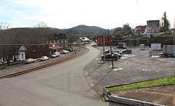
Two major rail lines pass through the Town of Bulls Gap, one running in a northeasterly-southwesterly direction and the other in a northwesterlysoutheasterly direction. The two lines are connected by a number of spur lines that form a triangular area. The commercial section of old Bulls Gap is centered along this triangular area of tracks.
The majority of the buildings in the district are located along South Main Street, a long winding road that runs primarily in a north-south direction. The northernmost end of South Main Street begins at U.S. Route 11E and Tennessee State Route 66 and continues downhill. The northern end of South Main Street is primarily residential and the residential section extends a short way beyond the bridge until the second major turn in the road. At this point the commercial area begins with several store buildings centered around the tracks and the site of the former train depot. After South Main Street crosses the tracks and Church Street, the district once again becomes residential.
Forty-eight buildings and eight structures are considered as contributing resources to the Bulls Gap Historic District. Contributing buildings include twenty-two residences, two churches, ten commercial buildings, and fourteen outbuildings. Contributing structures include three water towers, two bridges, and three outbuildings.
In 1792 John Bull, a gunsmith, received a North Carolina land grant for fifty-five acres of land on Bays Mountain near an important east-west passageway over the mountain. Bull operated a stageline through this passageway which became known as Bull's Gap. Little information is known about the early settlement of Bulls Gap.
Because of the important railroad line through the mountains, Bulls Gap became a strategically important location for both sides of the Civil War. Bulls Gap became a fortified town and between 1863 and 1865 many battles were fought to gain control of the town and its railroad. Throughout most of the war, the Union Army retained control of Bulls Gap and the railroad.