
Country Philippines Barangays Area 175.9 km² Local time Monday 4:08 PM | Founded February 9, 1942 Time zone PST (UTC+8) Province Benguet | |
 | ||
Region Cordillera Administrative Region (CAR) District Lone district of Benguet Weather 21°C, Wind W at 3 km/h, 82% Humidity Neighborhoods Abatan, Natubleng, Nabalicong, Dalimona, CARD Incorporated, Buguias Unit | ||
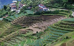
Road to abatan buguias benguet
Buguias, officially the Municipality of Buguias (Ilocano: Ili ti Buguias; Filipino: Bayan ng Buguias), is a municipality in the province of Benguet in the Cordillera Administrative Region (CAR) of the Philippines. The population was 43,627 at the 2015 census. In the 2016 electoral roll, it had 20,133 registered voters.
Contents
- Road to abatan buguias benguet
- Map of Buguias Benguet Philippines
- Etymology
- Spanish period
- American period
- Post war era
- Geography
- Barangays
- Demographics
- Economy
- Education
- Historical markers and shrine
- References
Map of Buguias, Benguet, Philippines
Etymology
According to folklore, Buguias got its name from the word bugas (or begas) which means "rice".
Another version of its origin would be an Igorot settlement during the pre-Spanish time called Bogey-yas, which was modernized and spelled as Buguias by Spanish authorities.
Spanish period
The arrival of Spanish colonizers in Buguias were primarily due to the construction of Spanish trails leading to the mountain region. Buguias and Loo were two separate rancherias during the Spanish Regime.
American period
During the American rule, Buguias was established as one of the 19 townships of the province of Benguet, upon the issuance of Act No. 48 by the Philippine Commission on November 22, 1900.
On November 23, 1900, the township of Loo was abolished and integrated into the township of Buguias with the issuance of Act No. 49.
On August 13, 1908, Benguet was established as a sub-province of the newly created Mountain Province with the enactment of Act No. 1876. As a result, six townships of Benguet were abolished, but Buguias remained a constituent town of Benguet sub-province.
Post-war era
On June 25, 1963, President Diosdado Macapagal issued Executive Order No. 42 converting eight (8) of the thirteen (13) towns (designated as municipal districts) of Benguet sub-province into regular municipalities. Buguias was among them.
On June 18, 1966, the sub-province of Benguet was separated from the old Mountain Province and was converted into a regular province. Buguias remained to be a component municipality of the newly established province.
Geography
Buguias is located at 16°43′N 120°50′E, at the northeastern section of Benguet. It is bounded by Mankayan on the north-west, Bakun on the mid-west, Kibungan on the south-west, Kabayan on the south, Tinoc on the east, Hungduan on the north-east, and Bauko on the north.
According to the Philippine Statistics Authority, the municipality has a land area of 175.88 square kilometres (67.91 sq mi) constituting 7000635000000000000♠6.35% of the 2,769.08-square-kilometre- (1,069.15 sq mi) total area of Benguet.
Buguias is 83 kilometres (52 mi) away from Baguio.
Barangays
Buguias is politically subdivided into 14 barangays.
Demographics
In the 2015 census, Buguias had a population of 43,627. The population density was 250 inhabitants per square kilometre (650/sq mi).
In the 2016 electoral roll, it had 20,133 registered voters.
Economy
Buguias is primarily an agricultural town. It is one of the leading producers of highland vegetables, especially carrots, in the province of Benguet.
Most of the vegetables produced in the town are sold at the La Trinidad Vegetable Trading Post or are marketed to other parts of the country.
Education
As of 2014, Buguias has 43 public elementary schools and 6 public secondary schools.
Historical markers and shrine
The Veteran Memorial Marker marks the liberation of Abatan and Buguias on July 27, 1945, that was fought between the Japanese Imperial Army and the combined Filipino and American ground troops. Through municipal council resolution No. 19, July 27, 1945 was declared as the Liberation Day and local holiday in the municipality. Festivals during this date include parades, programs and wreath-laying.
The World War II 66th Infantry Shrine monument, located in Lengaoan along Halsema Highway, symbolizes the bravery of the combined Filipino and American soldiers who stood their ground defending the area and firing their cannons against the Japanese forces.