Population 4,164 Sovereign state United Kingdom Local time Monday 7:57 AM | OS grid reference SX015589 Post town ST. AUSTELL Dialling code 01726 | |
 | ||
Weather 6°C, Wind W at 13 km/h, 90% Humidity | ||
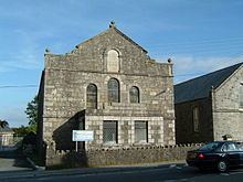
Bugle is a village in mid Cornwall, England, United Kingdom. It is in the parish of Treverbyn (where the 2011 Census population was included) and is situated about five miles (8 km) north of St Austell on the A391 road. The 2011 Census for the ward of Bugle which includes Treverbyn and surrounding hamlets gave a population of 4,164.
Map of Bugle, Saint Austell, UK
The village was established in the mid 19th century following the construction of: a turnpike road in 1836-7; the Bugle Inn in 1840; and the Par to Bugle section of the Treffry Tramways in 1842.
The village has a railway station on the Atlantic Coast Line.
Bugle F.C. were South Western League champions in 1984/85. The Bugle Silver Band has been in existence since 1868 and has been successful in many regional competitions.
There are plans to build a new neighbourhood on the site of the Goonbarrow Refinery west of the village as part of the St Austell and Clay Country Eco-town. This would include 450-550 homes. The plan was given outline approval in July 2009.
