
- location east of Saunders - location Man Length 30 km Basin area 116.5 km² Country United States of America | - elevation 2,602 ft (793 m) - elevation 725 ft (221 m) Basin area 116.5 km² Mouth Guyandotte River | |
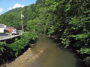 | ||
Buffalo Creek is a tributary of the Guyandotte River, 18.8 miles (30.3 km) long, in southern West Virginia in the United States. Via the Guyandotte and Ohio rivers, it is part of the watershed of the Mississippi River, draining an area of 45 square miles (120 km2) in the Logan Coalfield. The creek was the site of the Buffalo Creek Flood in 1972.
Map of Buffalo Creek, Eastern, WV, USA
Buffalo Creek's entire course and drainage area are in eastern Logan County. It rises near the common boundary of Logan, Wyoming, and Boone counties and flows generally west-southwestward through the unincorporated communities of Saunders, Pardee, Lorado, Craneco, Lundale, Stowe, Crites, Latrobe, Robinette, Amherstdale, Becco, Braeholm, Accoville, Crown, and Kistler, to the town of Man, where it flows into the Guyandotte River from the northeast.
According to the West Virginia Department of Environmental Protection, approximately 92% of the Buffalo Creek watershed is forested, mostly deciduous.