
OS grid reference TQ2251 Sovereign state United Kingdom Local time Sunday 11:40 PM | Civil parish Buckland Area 5.51 km² Dialling code 01737 | |
 | ||
Population 562 (Civil Parish 2011) Weather 6°C, Wind W at 26 km/h, 88% Humidity | ||
Buckland is a village and civil parish in the Mole Valley district of Surrey, England, between Dorking and Reigate, its nearest towns. The civil parish is bordered by the North Downs escarpment in the north. The area contains a number of clay pits.
Contents
Map of Buckland, UK
History
Buckland appears in Domesday Book (of 1086) as Bochelant. It was owned by John of Tonbridge. Buckland had a church, watermill and thirty-five heads of household. Of these, seventeen farmed the land owned by the feudal lord, and ten were more lowly servants (serfs) of the estate.
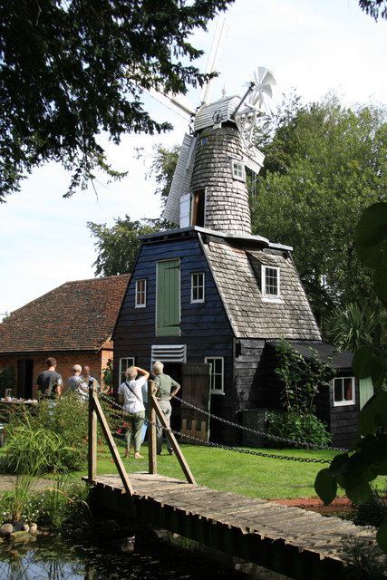
The village church St Mary the Virgin was built in 1380. The windmill is a tourist focal point.
Local legend
Buckland is also the location of the Shag Brook, which local legend says was the home of a monstrous horse (in some versions a gorilla), called the Buckland Shag. This beast would drag travellers from the nearby coaching road and devour them on the Shag Stone, a large boulder in the brook with a blood red vein of iron ore running through it.
The local parson, Willoughby Bertie, had the Shag Stone removed from the brook in 1757 and thrown from a cliff in Devon. The Buckland Shag then disappeared from local folklore.
The legend of the Buckland Shag has recently been revived by a local morris side, The Buckland Shag Morris Men.
Governance
Surrey County Council elected every four years, has one representative, from Buckland for Dorking Rural:
The second party forming the main local opposition in the 2009 election, was the Liberal Democrats gaining 1956 votes versus the winning candidate's 2225.
2 councillors sit on Mole Valley borough council, who are:
Demography and housing
The average level of accommodation in the region composed of detached houses was 28%, the average that was apartments was 22.6%.
The proportion of households in the civil parish who owned their home outright compares to the regional average of 35.1%. The proportion who owned their home with a loan compares to the regional average of 32.5%. The remaining % is made up of rented dwellings (plus a negligible % of households living rent-free).
Transport
The A25 runs east–west through the parish. No dual carriageways are in the parish.
The nearest railway station is centred 1 mile (1.6 km) WNW of the village centre, Betchworth railway station and is also on an east–west line.