
Time zone CST (UTC-6) GNIS feature ID 0474525 Area 111 ha Population 313 (2013) Area code 620 | County Bourbon FIPS code 20-08475 Elevation 326 m Zip code 66716 Local time Friday 11:35 PM | |
 | ||
Country United States of America Weather 11°C, Wind S at 27 km/h, 35% Humidity | ||
Tornado in bronson kansas
Bronson is a city in Bourbon County, Kansas, United States. As of the 2010 census, the city population was 323.
Contents
- Tornado in bronson kansas
- Map of Bronson KS 66716 USA
- Bronson kansas t ball clip 12
- History
- Geography
- 2010 census
- 2000 census
- Education
- Notable people
- References
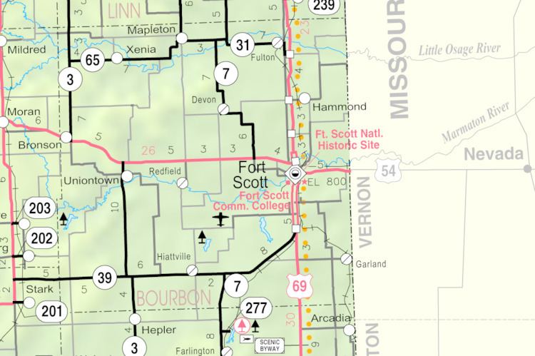
Map of Bronson, KS 66716, USA
Bronson kansas t ball clip 12
History
Bronson was founded in the 1880s. The first store and post office opened in September 1881. The city was formerly named Wilsonville, but it was later renamed after Ira Bronson, a Fort Scott attorney. Bronson was moved to its current location when the Missouri Pacific Railroad bypassed the original town site.
Midway between Fort Scott and Iola on the highway and railroad, it became a prime shipping and supply point for the agricultural region. Growth was slow but steady. From a handful of residents in 1885, by the 1910 Census Bronson had 595 residents. In 1912 it had two banks, an international money-order post office with four rural routes, express and telegraph offices, telephone connections, the semi-weekly Bronson Pilot newspaper, a downtown retail district and public schools.
In 1910 Bronson held the world's first horseshoe pitch tournament.
Geography
Bronson is located at 37°53′48″N 95°4′21″W (37.896562, -95.072520). According to the United States Census Bureau, the city has a total area of 0.43 square miles (1.11 km2), all of it land. U.S. Route 54 intersects K-3 on Bronson's east side.
2010 census
As of the census of 2010, there were 323 people, 131 households, and 83 families residing in the city. The population density was 751.2 inhabitants per square mile (290.0/km2). There were 153 housing units at an average density of 355.8 per square mile (137.4/km2). The racial makeup of the city was 90.1% White, 3.4% African American, 0.9% Native American, 3.7% from other races, and 1.9% from two or more races. Hispanic or Latino of any race were 6.2% of the population.
There were 131 households of which 32.8% had children under the age of 18 living with them, 47.3% were married couples living together, 13.0% had a female householder with no husband present, 3.1% had a male householder with no wife present, and 36.6% were non-families. 34.4% of all households were made up of individuals and 17.6% had someone living alone who was 65 years of age or older. The average household size was 2.47 and the average family size was 3.17.
The median age in the city was 39.6 years. 28.8% of residents were under the age of 18; 5.5% were between the ages of 18 and 24; 21.5% were from 25 to 44; 27.5% were from 45 to 64; and 16.7% were 65 years of age or older. The gender makeup of the city was 46.4% male and 53.6% female.
2000 census
As of the census of 2000, there were 346 people, 147 households, and 93 families residing in the city. The population density was 814.3 people per square mile (318.1/km²). There were 164 housing units at an average density of 386.0 per square mile (150.8/km²). The racial makeup of the city was 94.51% White, 2.31% African American, 2.02% Native American, 0.29% Asian, 0.29% Pacific Islander, and 0.58% from two or more races. Hispanic or Latino of any race were 0.58% of the population.
There were 147 households out of which 31.3% had children under the age of 18 living with them, 53.1% were married couples living together, 8.8% had a female householder with no husband present, and 36.1% were non-families. 34.7% of all households were made up of individuals and 20.4% had someone living alone who was 65 years of age or older. The average household size was 2.35 and the average family size was 3.06.
In the city, the population was spread out with 27.2% under the age of 18, 6.6% from 18 to 24, 24.6% from 25 to 44, 24.6% from 45 to 64, and 17.1% who were 65 years of age or older. The median age was 39 years. For every 100 females there were 98.9 males. For every 100 females age 18 and over, there were 85.3 males.
The median income for a household in the city was $26,806, and the median income for a family was $32,656. Males had a median income of $25,588 versus $21,563 for females. The per capita income for the city was $12,332. About 11.4% of families and 13.8% of the population were below the poverty line, including 17.5% of those under age 18 and 23.9% of those age 65 or over.
Education
Bronson is served by USD 235 Uniontown. The Uniontown High School mascot is Eagles.
Bronson schools were closed through school unification. The Bronson high school mascot was Bulldogs.