
Population 1,728 (2011 Census) Civil parish Lower Broadheath Country England Local time Saturday 1:07 AM District Malvern Hills District | OS grid reference SO8156 Region West Midlands Sovereign state United Kingdom Shire county Worcestershire UK parliament constituency West Worcestershire | |
 | ||
Weather 9°C, Wind SE at 13 km/h, 89% Humidity | ||
Broadheath with Lower Broadheath is a civil parish officially known as Lower Broadheath, in the Malvern Hills district of Worcestershire, England. According to the 2011 census it had a population of 1,728. The parish also includes Upper Broadheath.
Map of Broadheath, Worcester, UK
The village is about 3 miles north-west of Worcester.
There are many housing estates in the village, including the Jacomb estate (Jacomb Road, Jacomb Drive, Jacomb Close and Rectory Close).
The village has a village hall, church, post office and shop, a village green (containing a football pitch, running track and many children's play areas) and a large village common. There is also a primary school (Broadheath C.E. Primary School). The school contains around 150 children, from the age of four up to eleven. There are also three pubs in the village.
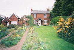
Broadheath is the birthplace of the English composer Edward Elgar. The cottage in which he was born is now a museum.