
Line IND Rockaway Line Platforms 2 side platforms Borough Queens Tracks 2 | Structure At-grade Opened 28 June 1956 Locale Broad Channel | |
 | ||
Division B (IND, formerly LIRR Rockaway Beach Branch) Services A (all times)
S (all times) Transit connections MTA Bus: Q52, Q53, QM16, QM17 Address Queens, NY 11693, United States Similar Beach 90th Street, Beach 98th Street, Aqueduct Racetrack, Beach 105th Street, Aqueduct–North Conduit Avenue | ||
Broad Channel is a station on the IND Rockaway Line of the New York City Subway, located in the neighborhood of the same name at Noel and West Roads in the borough of Queens. It is served by the A train and the Rockaway Park Shuttle at all times, the latter of which originates/terminates here.
Contents
History
The station originally opened in 1880 as a New York, Woodhaven and Rockaway Railroad station (although some sources claim it opened in June 1881), that was acquired by the Long Island Rail Road and became a station on the Rockaway Beach Branch. As a Long Island Rail Road station it served as one of two junctions between the Far Rockaway and Rockaway Beach Branches. The other junction was at Hammels Station, although it was originally a junction for the Far Rockaway Branch and the Ocean Electric Railway. Wooden shelter sheds were added to the station in 1921 and 1923. A fire on the trestle between this station and another one known as The Raunt forced the closure of both stations on May 23, 1950, as well as the entire Jamaica Bay trestle.
By October 3, 1955, the entire Rockaway Beach Branch south of Ozone Park, and all of the Far Rockaway Branch west of Far Rockaway was purchased by the New York City Transit Authority. The Broad Channel station was entirely reconstructed (as were the Howard Beach and Far Rockaway stations) with new concrete platforms, and a new station house. The contract for the new station was approved in December 1954. The station opened to subway service on June 28, 1956.
In 1985, the station had only 224 paying daily riders on a typical weekday not counting farebeaters, making it one of the least used stations in the system.
The station and the adjacent segment of the Rockaway Line suffered serious damage during Hurricane Sandy in 2012, and was out of service for several months. Due to its location in the middle of Jamaica Bay, the station was filled with debris, with its trackbed damaged. During its temporary closure, the station received new ADA-tactile strips, platform edge rubbing boards, and cosmetic and mechanical work. Service was restored to the station on May 30, 2013.
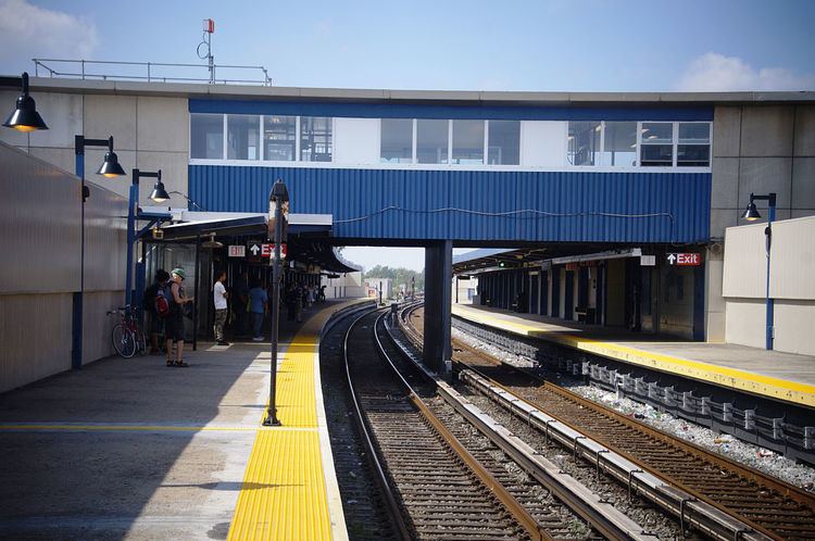
Station layout
This station has two tracks and two side platforms, each measuring 12 feet (3.7 m) wide and over 660 feet (200 m) long. The platforms are sheltered with canopies and windscreens.
Exit
A station house is located above both platforms, containing a crossover, waiting area and fare control. The single street staircase outside of fare control goes down to West Road by the intersection of Noel Road next to the Rockaway-bound platform. This platform also has a set of exit-only turnstiles leading directly to this staircase so riders exiting the station on this side do not have to go through the station house. The station house is heated, while the platforms feature passenger-activated heaters; these heaters, and the doors separating the station house and staircases, were not originally part of the station. The station house originally had 1950s-era signage at its front entrance reading "SUBWAY", but now only has modern MTA entrance signs.
At the north end of the station is a power substation, located at West Road and East 6th Road adjacent to the Rockaway-bound platform. A second exit-only staircase is located here, but is closed.
Track layout
Just to the north, the Rockaway Line gains two extra non-revenue tracks straddling the two revenue tracks. The western track is a test track, installed in 2001 and called the Far Rockaway Test Track, while the eastern track is used to relay shuttle trains. The western track extends around 10,000 feet (3,000 m) or 2 miles (3.2 km), while eastern track is long enough for one full-length train and ends at a bumper block.
Continuing north, the Rockaway Line crosses Jamaica Bay before reaching Howard Beach; the distance of 3.5 miles (5.6 km) between the two stations is the longest between any two in the New York City Subway system. To the south, the Rockaway Line continues to the Rockaway peninsula, where it splits at Hammels Wye to allow service to both Far Rockaway–Mott Avenue and Rockaway Park–Beach 116th Street. Punch boxes are located at the ends of both platforms, to allow train operators to select the correct route.
Ridership
Broad Channel is a small island with fewer than 3,000 residents, and the station has the second-lowest ridership in the subway system as of 2015, with 91,766 annual riders, or 310 riders per weekday. It was only trailed by a closed station, making Broad Channel the least used of any fully operating subway station in the city. However, it is the only transfer point between the A train and the Rockaway Park Shuttle, and most riders use it in this capacity.
Nearby points of interest include a visitor center and trails for the Gateway National Recreation Area's Jamaica Bay Wildlife Refuge.