
Type Tiered Horsetails Longest drop 322 ft (98 m) Averageflow rate 40 cu ft/s (1.1 m/s) | Total height 1,291 ft (393 m) Watercourse Bridal Veil Creek Number of drops 7 | |
 | ||
Similar Cascade Range, Mount Index, Wallace Falls State Park, Heybrook Lookout Trailhead, Twin Falls | ||
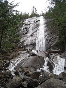
Bridal Veil Falls is a 1,328-foot (405 m) waterfall that flows from Lake Serene directly to the South Fork Skykomish River on the creek of the same name in the U.S. state of Washington. It is a perennial 150-foot (46 m) wide drop with four tiers, two of which (350 feet (110 m) and 250 feet (76 m), respectively) are clearly visible. It is at 47.78950°N 121.56924°W / 47.78950; -121.56924.
Map of Bridal Veil Falls, Washington, USA
Bridal Veil Falls is part of the Mount Baker-Snoqualmie National Forest. A hiking trail leads from a parking area to the falls.
References
Bridal Veil Falls (Washington) Wikipedia(Text) CC BY-SA