
Type Natural, oligotrophic Average depth 6 feet (1.8 m) Max depth 7.62 m Shore length 2.6 km | Basin countries United States Surface elevation 1,678 m Mean depth 1.8 m Water volume 493,400 m³ | |
 | ||
Primary inflows Catchment area 1.4 square miles (3.6 km) Outflow location | ||
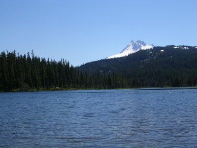
Breitenbush Lake is a 65-acre (26 ha) water body on a high plateau north of Mount Jefferson in the Cascade Range in the U.S. state of Oregon. The lake, fed by seepage and small creeks, is part of the North Fork Breitenbush River watershed. It is in Marion County near its border with Jefferson County and lies within the Mount Hood National Forest and the Warm Springs Indian Reservation at an elevation of about 5,500 feet (1,700 m).
Map of Breitenbush Lake, Oregon, USA
Forest Road 4220 runs by the lake. Breitenbush Lake Campground, maintained by the United States Forest Service, has 20 sites and a vault toilet but no garbage service. Canoes are allowed on the lake but not motorboats. The lake, which supports rainbow and brook trout generally ranging in length from 6 to 12 inches (15 to 30 cm), is stocked periodically.
Forest Road 4220 has been described as rough at best, and heavy snow keeps it closed to most traffic from mid-October through the end of June, usually. When the road is snow-covered, visitors can still use it to reach the lake on snowshoes, cross-country skis, or snowmobiles.