
Population 4,019 (2001 Census) Sovereign state United Kingdom Local time Thursday 5:59 PM | OS grid reference TF021673 Post town LINCOLN Dialling code 01522 | |
 | ||
Weather 7°C, Wind SW at 26 km/h, 57% Humidity UK parliament constituency Sleaford and North Hykeham | ||
Branston is a large village in the North Kesteven district of Lincolnshire, England. The village is situated approximately 4 miles (6 km) south-east from the city and county town of Lincoln. It is the principal settlement in the civil parish of Branston and Mere (where is population is currently recorded).
Contents
Map of Branston, Lincoln, UK
In the 2001 Census the population of the parish was recorded as 4019.
History
The 1086 Domesday Book records a village population as 350, a figure which stayed relatively stable until the beginning of the 20th century when the population began to quickly increase to the current total. The character of the village has changed much over the second half of the 20th Century but the village has retained much of its historic centre – where the majority of buildings are constructed from local limestone.
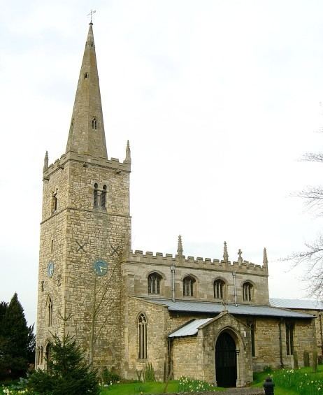
The village's most notable buildings are Branston Hall and Branston All Saints' Church. There is a rectory house, built in 1765. A now redundant Methodist chapel, built in 1847, is of Gothic style and previously seated 300. A Methodist chapel with seating for 110 was built to the north-east of the village at Branston Moor in 1911.
A war memorial to men of the parish killed in the First World War was erected on the village green in 1920.
The village used to have a railway station which was in the parish of Heighington.
The civil parish of Branston was merged in 1931, with that of Mere, to form the present unit. In the early 1930s parish occupations included twenty-one farmers and one smallholder, two poultry breeders, a horse dealer, a haulage contractor, two coal dealers, a motor bus proprietor, a cycle dealer, a fried fish dealer, three blacksmiths, a wheelwright, a plumber, two carpenters, a boot maker, two butchers, two grocers, three shopkeepers, two tailors, one of whom ran the post office, and landlords of the Waggon and Horses, Plough and Horses, Green Tree, and Anchor public houses.
In July 1977 more than fifty children from the junior school had to go to Lincoln County Hospital after a crop spraying aircraft inadvertently sprayed their playground. The insecticide was a mixture of meta-systox and aphox; organophosphate and carbamate compounds designed to clear crops of aphids.
Geography
The village of Branston is on the B1188 road, from Canwick near Lincoln, to Holdingworth near Sleaford. It is built around the shallow valleys of two limestone steams that flow northwards toward Washinborough, to join the River Witham. Most of the village is around 45m above sea level.
Amenities
Branston has one public house, the Waggon and Horses, a modern building which stands on the High Street close to the historic centre of the village. About 110 yards (100 m) farther along the High Street is the Home Guard Club, a private members club. Two other public houses were once located in the village. The Plough which stood on the High Street opposite the Waggon and Horses, which was demolished in the 1970s to straighten a dangerous bend at the centre of the village, and the Bertie Arms, a small public house on Rectory Lane, long ago converted into a private dwelling. Pottergate Golf Club is on Moor Lane.
Education
Branston's secondary school is Branston Community Academy, situated on the outskirts of the village on the road to Heighington; the public library is situated in the school. On the same road next to the Co-op is Branston Junior School, the village primary school. Branston C of E Infant School is located on the Valley Estate, which lies on the northern side of the village, close to the main road to Lincoln.