
Country United States County Suwannee FIPS code 12-08175 Elevation 13 m Zip code 32008 Local time Thursday 12:19 PM | State Florida Time zone Eastern (EST) (UTC-5) GNIS feature ID 0279335 Area 210 ha Population 723 (2013) Area code 386 | |
 | ||
Weather 17°C, Wind N at 16 km/h, 84% Humidity | ||
Visiting family in branford florida lafayette county
Branford is a town in Suwannee County, Florida, United States. The population was 712 at the 2010 census.
Contents
- Visiting family in branford florida lafayette county
- Map of Branford FL 32008 USA
- Geography
- Demographics
- Branford Springs
- References
Map of Branford, FL 32008, USA
Geography
Branford is located at 29°57′42″N 82°55′38″W (29.961803, -82.927204).
The town is located on the banks of the Suwannee River. U.S. Route 27 and U.S. Highway 129 intersect in Branford.
According to the United States Census Bureau, the town has a total area of 0.8 square miles (2.1 km2), all land.
Branford is located (depending on the route of travel) approximately:
Demographics
As of the census of 2010, there were 712 people, 277 households, and 185 families residing in the town. The population density was 890 people per square mile (323.3/km²). There were 347 housing units at an average density of 386.1 per square mile (148.9/km²). The racial makeup of the town was 80.2% White, 6.9% African American, 0.8% Native American, 1.7% Asian, Hispanic or Latino of any race were 13.2% of the population.
There were 277 households out of which 35.7% had children under the age of 18 living with them, 40.4% were married couples living together, 20.6% had a female householder with no husband present, and 33.2% were non-families. 27.8% of all households were made up of individuals and 14.8% had someone living alone who was 65 years of age or older. The average household size was 2.57 and the average family size was 3.06.
In the town, the population was spread out with 30.8% under the age of 19, 6.6% from 20 to 24, 27.5% from 25 to 44, 21.5% from 45 to 64, and 13.7% who were 65 years of age or older. The median age was 32.9 years.
The median income for a household in the town was $32,679, and the median income for a family was $36,625. The per capita income for the town was $17,353. About 24.9% of families and 29.2% of the population were below the poverty line, including 29.4% of those under age 18 and 12.6% of those age 65 or over.
Branford is served by two Public Schools, Branford Elementary School and Branford High School.
A public library is open 6 days per week on Suwannee Avenue.
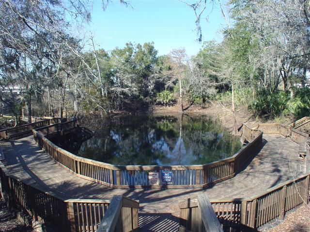
Branford Springs
On the Suwannee River, Branford Springs within the town is a popular diving spot.