
Population 198 Sovereign state United Kingdom | OS grid reference TA243068 Local time Thursday 11:53 AM | |
 | ||
Weather 8°C, Wind W at 29 km/h, 67% Humidity | ||
Bradley is a village and civil parish in North East Lincolnshire, England. It is situated approximately 3 miles (5 km) south-west from Grimsby and 2 miles (3 km) north from Barnoldby le Beck. Its population recorded in the census for both 2001 and 2011 was 198.
Map of Bradley, UK
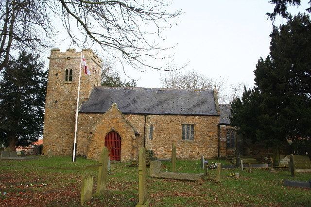
Bradley Grade II* listed Anglican parish church is dedicated to St. George. Originating in the 12th century, it is of partly Norman origin. Restoration of the chancel and installation of electric lighting took place in 1928. The parish register dates from 1664. In the early 1930s, there existed a small Methodist chapel. Poorer children in the parish were educated at a free school at Laceby, 2 miles (3 km) away. Parish occupations included four farmers, a poultry farmer, and a fruit grower.
To the south of the village, within the parish boundary, are Bradley Woods and the Dixons Wood Nature Reserve. To the east, within the Grimsby boundary, lies the Bradley Recreation Ground and beyond that the Bradley Park Estate. The land on which these stand was part of Bradley parish until 1928.