
Primary inflows Basin countries Canada Max. width 2 km (1.2 mi) Surface elevation 984 m Length 10 km Province Alberta Inflow source Athabasca River | Primary outflows Athabasca River Max. length 10 km (6.2 mi) Surface area 14.5 km (5.6 sq mi) Area 14.5 km² Width 2 km Outflow location Athabasca River | |
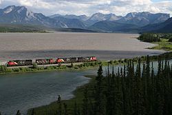 | ||
Brûlé Lake is a lake in western Alberta, Canada. It is formed along the Athabasca River, immediately east of Jasper National Park and 30 km west of Hinton. According to one tradition, the lake was named for a burnt (French "brûlé") tract of woods near the site.
Map of Br%C3%BBl%C3%A9 Lake, Yellowhead County, AB, Canada
The Brûlé Lake sand dunes are a popular place for all-terrain vehicle driving.
The main line of the Canadian National Railway—which is also used by Via Rail's Canadian passenger train—passes on the western side of the lake, while the Yellowhead Highway passes on the eastern side.
The lake lies at an elevation of 984 m, is 10 km long, and has a maximum width of 2 km. The total water area is 14.5 km2.
Between 1799 and 1801, Hudson's Bay Company had a trading post established on the shores of the lake.