
Country United States County Wayne Elevation 585 ft (178 m) | State Michigan City Detroit Time zone EST (UTC-5) | |
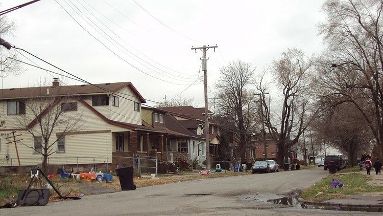 | ||
Boynton and Oakwood Heights are the two southernmost neighborhoods of the city of Detroit, Michigan. According to the United States Census Bureau, the two neighborhoods occupy a total of 2.80 square miles (7.3 km²). Boynton and Oakwood Heights had a combined population of 8,832 at the 2010 census, which was a 21.9% decrease from its population of 10,516 in 2000 census. The two occupy the entirety of the 48217 ZIP code.
Contents
Located in the heavily industrialized southwestern portion of Detroit, Boynton and Oakwood Heights are densely populated yet highly polluted by industries in and around the neighborhoods. In several articles published in July 2010, the Detroit Free Press ranked the neighborhoods of Boynton and Oakwood Heights as the most polluted ZIP code in the state of Michigan.
Geography
Boynton and Oakwood Heights occupy the southernmost 2.80 square miles (7.3 km²) of the city of Detroit. It is the only area of the Detroit city limits that fall south of the River Rouge. It extends as far down as Outer Drive on the border of Lincoln Park. Boynton is the southernmost of the two neighborhoods, stretching from the Outer Drive–Interstate 75 exit 42 southeast along Outer Drive until approximately Bassett Street, which enters the city of Ecorse. Interstate 75 serves as the Detroit border with the city of Melvindale from exits 42 to 43 (Schaefer Highway). Oakwood Heights occupies the area northwest of the Interstate 75–Schaefer Highway junction, while Boynton occupies the Detroit city limit east of Interstate 75.
The Boynton and Oakwood Heights neighborhoods share their borders with the city of Lincoln Park on the south, Ecorse and River Rouge on the east, Melvindale on the west, and Dearborn on the northwest. Across the River Rouge, Boynton and Oakwood Heights connect to the rest of Detroit—bordering the neighborhoods of Carbon Works and Delray on the opposite side of the river.
Oakwood Heights connects to Fordson Island in the River Rouge via Riverside Drive, although Fordson Island is under the jurisdiction of Dearborn. The small island has no residents.
Demographics
According to data from the 2010 census, the areas of Boynton–Oakwood Heights had 8,832 people and 3,126 occupied households for an average density of 5,428.4 people per square mile (2,095.9/km²). There were 716 vacant units.
According to 2009 estimates, the racial makeup of the two neighborhoods was 10.38% White, 74.80% African American, 0.67% Native American, 0.46% Asian, 0.10% Pacific Islander, 0.01% from other races, and 2.60% from two or more races. Hispanic or Latino of any race were 10.94% of the population. 2009 estimates were off significantly from official counts later recorded at the 2010 census. While there was estimated to be 12,129 residents in 2009, the census officially accounted for only 8,832. The majority of the population lives in Boynton.
The median income for a household in these neighborhoods was $26,316, and the median income for a family was $28,789. About 27.3% of the population was below the poverty line.
Transportation
Interstate 75, known locally as the Fisher Freeway, runs north through the Boynton and Oakwood Heights neighborhoods and has two exits: Outer Drive (#42) and Schaefer Highway (#43). Outer Drive represents the southernmost border of the Boynton neighborhood and the southernmost city limit of Detroit. The Schaefer Highway (also referred to as the Coolidge Highway at various points along its route) runs northwest through the neighborhoods. Fort Street (formerly U.S. Route 25) runs north through the middle of the neighborhoods and crosses the River Rouge. Several Norfolk Southern Railway lines runs through the Oakwood Heights section.
Oakwood Heights has one property listed on the National Register of Historic Places: the Fort Street – Pleasant Street and Norfolk & Western Railroad Viaduct, which was constructed in 1928. The 2,800 foot (850 m) long bridge carries six lanes of Fort Street over Pleasant Street and four railway lines before Fort Street crosses the River Rouge.
The Detroit Department of Transportation operates two bus routes that travel through Boynton and Oakwood Heights. Route #41 travels along Schaefer Highway all the way from the city of River Rouge (where it is called Coolidge Highway), through parts of Dearborn, and to the northern limits of Detroit at 8 Mile Road at Oak Park. Route #19 travels along Fort, Schaefer, and Bassett in the Boynton area and connects to Downtown Detroit.
Education
Being a part of Detroit, residents of Boynton and Oakwood Heights are zoned to Detroit Public Schools.
Residents are zoned to Mark Twain School for elementary and middle school. High school students are zoned to Western International High School. High school students were previously zoned to Southwestern High School. Southwestern closed in 2012, and students were reassigned to Western..
Mark Twain is the only public school located within the Boynton–Oakwood Heights neighborhoods. Formerly known as the Frances G. Boynton School, it was built in 1926. In the 2011–12 school year, Mark Twain enrolled 277 students, of which 254 (91.7%) were African American and 251 (90.6%) total received free lunch.
On a previous occasion, some students in the area were zoned to the Phoenix Multicultural Academy in the Springwells neighborhood for elementary school. All area students were zoned to Mark Twain for middle school.
The only other school located within these neighborhoods is the Pierre Toussaint Academy, which is a charter school located at 2450 South Beatrice Street in Boynton. Managed by The Leona Group, it enrolls approximately 400 students in grades K–8.
While the two neighborhoods contain no public libraries, the nearest Detroit Public Library is the Campbell Branch at 8733 West Vernor Highway in the Springwells neighborhood. Also, the Lincoln Park Library is about one mile south of Boynton at 1381 Southfield Road in Lincoln Park.
Industry
Parts of the southwest area of the city area contain heavy industry, and this has reportedly raised health concerns for some residents living in Boynton–Oakwood Heights. While at least 14 states regulate and prohibit how close industries can build to schools and residential zones, Michigan does not have such regulations. The city zoned its southwest areas for heavy industrial use. Air pollution in Boynton–Oakwood Heights has reportedly led to respiratory diseases and cancer cases in long-term residents. In an article published by the Detroit Free Press in June 2010, they reported, "For the past six months, a rain of mysterious sparkly dust of unknown origin has landed on their homes and gardens. Odd odors and clouds of dark particles float overhead." This dust pollution has been shown to contain high levels of harmful metals, such as lead.
The Detroit Free Press stated that the 48217 ZIP code—occupied solely by Boynton and Oakwood Heights—is "Michigan's most polluted [zip code], according to analysis by environmental scientists from the University of Michigan." Halting the growing industries could discourage job growth, and the state continues to issue permits for heavy industries. Industries comply with both state and federal regulations. However, the number of industries proximate to the neighborhoods has a cumulative effect.
The largest of these industries is the Marathon Petroleum Company LP refinery located at 301 South Fort Street in Oakwood Heights. The refinery received the Energy Star Award in 2007 and 2008 from the Environmental Protection Agency for reducing energy usage and protecting the environment through energy efficiency. The refinery has added greenspace around its facility. On April 27, 2013 a tank containing diesel fuel exploded during maintenance work at the Marathon Detroit Refinery, forcing a mandatory evacuation order for the nearby area of Oakwood Heights. The refinery has received permission for an expansion of its facilities, which has received the support from some local residents who received a buyout to move out of the area. Marathon offered 350 homeowners buyout packages totaling nearly $60,000 per home in the Oakwood Heights community. A similar offer was requested but not granted to the Boynton community. Other large-scale industries, such as the Detroit Wastewater Treatment Plant, located on the other side of the River Rouge in the Delray neighborhood (48209 ZIP code), incinerates its waste, which further adds to the poor air quality in the area.