
Country United States Largest city Bowling Green | State(s) Kentucky Area 1,419 km² | |
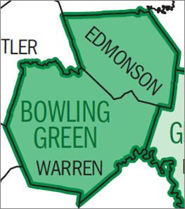 | ||
Other cities - Brownsville
- Scottsville
- Morgantown
- Smiths Grove
- Woodburn Highest elevation Pilot Knob 935 ft (285 m) Lowest elevation Confluence of the Green
and Barren Rivers
395 ft (120 m) | ||
The Bowling Green Metropolitan Statistical Area, as defined by the United States Census Bureau, is an area consisting of four counties in Kentucky, anchored by the city of Bowling Green. As of 2014, the MSA had an estimated population of 165,732.
Contents
Counties
Incorporated places
Unincorporated places
Demographics
As of the census of 2000, there were 104,166 people, 40,013 households, and 26,873 families residing within the MSA. The racial makeup of the MSA was 88.25% White, 7.68% African American, 0.26% Native American, 1.21% Asian, 0.07% Pacific Islander, 1.19% from other races, and 1.35% from two or more races. Hispanic or Latino of any race were 2.43% of the population.
The median income for a household in the MSA was $30,782, and the median income for a family was $38,493. Males had a median income of $29,417 versus $19,968 for females. The per capita income for the MSA was $16,664.