
Country United States County San Diego FIPS code 06-07596 Elevation 182 m Zip code 92004 Area code Area codes 442 and 760 | State California Time zone PST (UTC-8) GNIS feature IDs 1652675, 2407888 Area 112.4 km² Population 3,429 (2010) | |
 | ||
Borrego Springs is a census-designated place (CDP) in San Diego County, California. The population was 3,429 at the 2010 census, up from 2,535 at the 2000 census, made up of both seasonal and year-round residents. Borrego Springs is completely surrounded by Anza-Borrego State Park, the largest of California's State Parks.
Contents
- Map of Borrego Springs CA 92004 USA
- History
- Tourism
- Anza Borrego Desert State Park
- Geography and ecology
- Climate
- Night sky
- 2010
- 2000
- Government
- Attractions
- References
Map of Borrego Springs, CA 92004, USA
The village of Borrego Springs has a pueblo-style Visitor's Center & Chamber of Commerce, as well as two shopping malls, several restaurants, accommodation and individual shops. There are no stop lights in Borrego Springs and night time lighting is kept to a minimum to protect the views of the night sky.
A local landmark is the traffic roundabout between the airport and downtown, known as Christmas Circle. Every year in October, the community celebrates with the Borrego Days Desert Festival at Christmas Circle. The town includes a branch of the San Diego County Library.
History
The name of Anza-Borrego State Park is derived from a combination of Juan Baptista de Anza and "borrego" which is Spanish for little lamb, in honor of the local herds of bighorn sheep.
Tourism
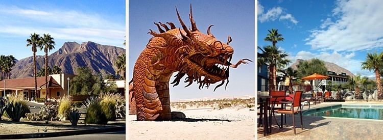
Tourism is a major industry in Borrego Springs. There are 4 public golf courses, Tennis Center, horseback riding and much more. The village is a popular destination for "Snow Birds" that migrate annually from the colder climates in winter to enjoy the sunshine of this desert community.
Anza-Borrego Desert State Park
The Anza-Borrego Desert State Park visitor's center is located west of town, with the park surrounding the town. This park encompasses more than 600,000 acres (2,400 km2), making it the largest desert state park in the nation.
Geography and ecology
According to the United States Geological Survey Borrego Springs is located at 33°15′24″N 116°22′30″W (33.2558717, -116.375012). This points at "Christmas Circle Drive", at the intersection of Palm Canyon Drive and Borrego Springs Road, which is where most maps place the community. According to the United States Census Bureau Borrego Springs is located at 33°14′50″N 116°22′19″W (33.247113, -116.371969). Located between "Frying Pan Road" and "Double O Road", this is 3,530 feet (1,080 m) south-southeast of the USGS location. According to the United States Census Bureau, the Borrego Springs census-designated place (CDP) has a total area of 43.4 square miles (112 km2), 99.22% of it land and 0.78% water.
The village is located on the floor of the Borrego Valley, which is widely acknowledged as the westernmost extent of the great southwestern geographical region known as the Sonoran Desert. Borrego Springs is situated on the valley floor within a diverse variety of desert flora and fauna. One of the iconic species found within the Borrego Springs area is the California Fan Palm, Washingtonia filifera, which is a lower risk/near-threatened species and the only palm native to the western United States. An abandoned Calcite Mine, which dates to World War II days, is situated on the northeast slope of the Santa Rosa Mountains in the park.
Climate
Average January temperatures are a maximum of 69.0 °F (20.6 °C) and a minimum of 43.4 °F (6.3 °C). Average July temperatures are a maximum of 106.8 °F (41.6 °C) and a minimum of 74.9 °F (23.8 °C). There are an average of 172.6 days with highs of 90 °F (32 °C) or higher and an average of only 2.6 days with lows of 32 °F (0 °C) or lower. The record high temperature was 122 °F (50 °C) on June 25, 1990. The record low temperature was 20 °F (−7 °C) on January 5, 1971. Average annual precipitation is 6.13 inches (156 mm) and there are an average of 24 days with measurable precipitation. The wettest year was 1983 with 18.73 inches (476 mm) and the driest year was 1953 with 1.35 inches (34 mm). The most rainfall in one month was 8.78 inches (223 mm) in January 1993. The most rainfall in 24 hours was 2.46 inches (62 mm) on March 2, 1983. Although snow rarely falls in the lowlands, 6.5 inches fell in December 1967.
Night sky
Borrego Springs is approximately 55 miles from the bright lights of the highly developed coast. Borrego Springs was designated as California's first International Dark-Sky Community by the International Dark-Sky Association. It is a center for public astronomy activities throughout the year.
2010
The 2010 United States Census reported that Borrego Springs had a population of 3,429. The population density was 79.0 people per square mile (30.5/km²). The racial makeup of Borrego Springs was 2,766 (80.7%) White, 20 (0.6%) African American, 34 (1.0%) Native American, 22 (0.6%) Asian, 5 (0.1%) Pacific Islander, 500 (14.6%) from other races, and 82 (2.4%) from two or more races. Hispanic or Latino of any race were 1,218 persons (35.5%).
The Census reported that 3,429 people (100% of the population) lived in households, 0 (0%) lived in non-institutionalized group quarters, and 0 (0%) were institutionalized.
There were 1,571 households, out of which 283 (18.0%) had children under the age of 18 living in them, 828 (52.7%) were opposite-sex married couples living together, 82 (5.2%) had a female householder with no husband present, 57 (3.6%) had a male householder with no wife present. There were 85 (5.4%) unmarried opposite-sex partnerships, and 13 (0.8%) same-sex married couples or partnerships. 507 households (32.3%) were made up of individuals and 262 (16.7%) had someone living alone who was 65 years of age or older. The average household size was 2.18. There were 967 families (61.6% of all households); the average family size was 2.76.
The population was spread out with 592 people (17.3%) under the age of 18, 165 people (4.8%) aged 18 to 24, 477 people (13.9%) aged 25 to 44, 1,044 people (30.4%) aged 45 to 64, and 1,151 people (33.6%) who were 65 years of age or older. The median age was 56.6 years. For every 100 females there were 99.5 males. For every 100 females age 18 and over, there were 100.4 males.
There were 2,611 housing units at an average density of 60.1 per square mile (23.2/km²), of which 1,235 (78.6%) were owner-occupied, and 336 (21.4%) were occupied by renters. The homeowner vacancy rate was 8.0%; the rental vacancy rate was 12.1%. 2,593 people (75.6% of the population) lived in owner-occupied housing units and 836 people (24.4%) lived in rental housing units.
2000
As of the census of 2000, there were 2,535 people, 1,153 households, and 727 families residing in the CDP. The population density was 59.6 inhabitants per square mile (23.0/km²). There were 2,280 housing units at an average density of 53.6 per square mile (20.7/km²). The racial makeup of the CDP was 82.8% White, 1.0% African American, 0.4% Native American, 0.2% Asian, 13.1% from other races, and 2.4% from two or more races. Hispanic or Latino of any race were 32.4% of the population.
There were 1,153 households out of which 19.1% had children under the age of 18 living with them, 53.6% were married couples living together, 6.4% had a female householder with no husband present, and 36.9% were non-families. 29.5% of all households were made up of individuals and 14.3% had someone living alone who was 65 years of age or older. The average household size was 2.20 and the average family size was 2.69.
In the CDP the population was spread out with 18.4% under the age of 18, 4.7% from 18 to 24, 21.2% from 25 to 44, 26.3% from 45 to 64, and 29.3% who were 65 years of age or older. The median age was 50 years. For every 100 females there were 105.9 males. For every 100 females age 18 and over, there were 105.7 males.
The median income for a household in the CDP was $37,045, and the median income for a family was $40,262. Males had a median income of $27,604 versus $26,023 for females. The per capita income for the CDP was $22,761. About 8.0% of families and 11.2% of the population were below the poverty line, including 16.0% of those under age 18 and 7.3% of those age 65 or over.
Government
In the California State Legislature, Borrego Springs is in the 38th Senate District, represented by Republican Joel Anderson, and in the 71st Assembly District, represented by Republican Randy Voepel.
In the United States House of Representatives, Borrego Springs is in California's 50th congressional district, represented by Republican Duncan D. Hunter.
Attractions
Members of the International Aerobatic Club have established a practice and competition area adjacent to and directly north of the Borrego Valley Airport. The area was first designated in 1976 and has an operational waiver approved by the Federal Aviation Administration. Aerobatic pilots from California and the southwest US regularly use the airspace for practice and major competitive events; users have included three past national champions. Visitors are welcome to come to the airport and watch the flight activity, which does not interfere with other airport operations. Two annual competition events are sponsored by the San Diego Aerobatic Club, the first in April and the second in October.
Sculptor Ricardo Breceda has made more than 100 large metal statues of animals that can be found in the area.