Population 7,604 (2011 census) Federal division Division of Rankin | Postcode(s) 4124 State electorate(s) Algester Postal code 4124 | |
 | ||
Location 27 km (17 mi) from Brisbane GPO | ||
Boronia Heights is a suburb of Logan City, Queensland, Australia.
Contents
Map of Boronia Heights QLD 4124, Australia
Geography
Boronia Heights lies to the west of Park Ridge.
History
Boronia Heights was known as the Logan Ridges through to the early 1890s.
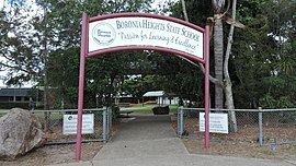
Boronia Heights State School opened on 29 January 1990.
Boronia Heights was gazetted as a suburb in October 1991 and was named after the first residential housing estate in the area.
Demographics
In the 2011 census, Boronia Heights recorded a population of 7,604 people, 51.6% female and 48.4% male.
The median age of the Boronia Heights population was 30 years, 7 years below the national median of 37.
71.4% of people living in Boronia Heights were born in Australia. The other top responses for country of birth were New Zealand 7.4%, England 3.4%, Philippines 1.1%, India 0.9%, Fiji 0.7%.
83.6% of people spoke only English at home; the next most common languages were 1.3% Samoan, 0.8% Urdu, 0.8% Hindi, 0.7% German, 0.5% Mandarin.
Education
The Boronia Heights State School, a government primary (P-6) school, is located at 194 Middle Road (27.684716°S 153.017723°E / -27.684716; 153.017723 (Boronia Heights State School)).
Amenities
The Boronia Bushland Reserve offers opportunities for bushwalking, barbecues and picnics. The bushland is home to many species of Australian fauna including eastern grey kangaroos, bandicoots, goannas, possums and koalas. The area has many scribbly gums, characterised by the scribbly lines on the otherwise smooth grey trunks.
