
OS grid reference SD493448 Post town Preston Dialling code 01995 | Sovereign state United Kingdom Postcode district PR3 District Wyre Civil parish Barnacre-with-Bonds | |
 | ||
Bonds is a village in Lancashire, England. It lies immediately south of Garstang town centre, on the opposite bank of the River Wyre. It is bounded by the Lancaster Canal to the south and west. It would appear, from its location, to be a suburb of Garstang, but it is in the separate civil parish of Barnacre-with-Bonds. Garstang, Bonds, Bowgreave and Catterall form an almost continuous built-up area, bypassed by the A6 road in 1928 (incorrectly given as 1926 in).
Map of Bonds, Preston, UK
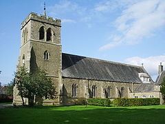
The Roman Catholic church of St Mary and St Michael is a Gothic Revival building consecrated in 1858, superseding a chapel built in 1784.
1⁄2 mile (800 m) east of the village is the ruin of Greenhalgh Castle, built in 1490 for Thomas Stanley.
References
Bonds, Lancashire Wikipedia(Text) CC BY-SA