
Elevation 150 m Volcanic arc Aleutian Arc | Designated 1967 Last eruption 1992 | |
 | ||
Island groups Aleutian Islands, Fox Islands Similar Kasatochi Island, Bobrof Island, Mount Pavlof, Mount Okmok, Makushin Volcano | ||
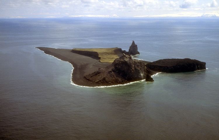
Bogoslof Island or Agasagook Island (Aleut: Aĝasaaĝux̂) is the summit of a submarine stratovolcano located along the southern edge of the Bering Sea, 35 miles (56 km) northwest of Unalaska Island of the Aleutian Island chain. It has a land area of 154 acres (0.62 km2) and is uninhabited by people. The peak elevation of the island is 490 feet (150 m). It is 1,040 metres (3,410 ft) long and 1,512 metres (4,961 ft) wide. The stratovolcano rises about 6,000 feet (1,800 m) from the seabed but the summit is the only part that projects above sea level.
Map of Bogoslof Island, Alaska, USA
The first known emergence of the island above sea level was recorded during an underwater eruption in 1796. Since then, parts of the island have been successively added and eroded. About 2,000 feet (610 m) north west of Bogoslof a small volcanic dome emerged in 1883 from the same stratovolcano, this has become a stack rock formation known as Fire Island . On the southwest side of Bogoslof another dome erupted in 1796; it is now called Castle Rock. Other eruptions have occurred in 1796-1804, 1806-1823, 1883-1895, 1906, 1907, 1909-1910, 1926-1928, 1992, and 2016-2017. The island is a breeding site for seabirds, seals, and sea lions. An estimated 90,000 tufted puffins, guillemots, red-legged kittiwakes and gulls nest here.
In 1909, President Theodore Roosevelt designated Bogoslof and Fire Island a sanctuary for sea lions and nesting marine birds. Together, as the Bogoslof Wilderness, they are currently part of the Aleutian Islands unit of Alaska Maritime National Wildlife Refuge. In November 1967, Bogoslof Island was designated a National Natural Landmark by the National Park Service. The Bogoslof Island group was added to the National Wilderness Preservation System in 1970.
A series of short volcanic eruptions on a nearly daily basis took place starting December 20, 2016, producing towering volcanic ash clouds and volcanic lightning, changing the geography of the island. As there are no cameras or monitoring stations on the island and the area is usually overcast details were uncertain. However, when the weather became favorable, it was seen that a small vent slightly offshore of Bogoslof's northeast beach had erupted explosively, fracturing the original island in two, and forming a new, smaller island to the northeast. Satellite images of the island showed that by December 25, 2016, the island had fractured into three smaller islands centered on what was thought to be the active vent of the eruption, gaining a net 1.2 acres (0.0049 km2), compared to its previous area of 71.2 acres (0.288 km2). Bogoslov continued to grow in the following weeks, reaching a size of 108.0 acres (0.437 km2) on January 11, 2017, and merging again into a single island. As of January 24, 2017, Bogoslov is 153.9 acres (0.623 km2) in size, having more than doubled in size, and forming into a large C-shaped island around the central vent, and will likely continue to grow. A significant explosive eruption began at Bogoslof volcano at 02:08 UTC on 20 February (17:08 AKST on 19 February). Seismic and infrasound data show a series of short-lived explosive pulses through 02:45 UTC; seismicity has been quiet since then. Recent satellite images show a cloud as high as 25,000 ft asl.