
Country United States Elevation 1,685 m | Time zone Pacific (PST) (UTC-8) Local time Sunday 2:15 PM | |
 | ||
Weather -5°C, Wind SW at 19 km/h, 85% Humidity | ||
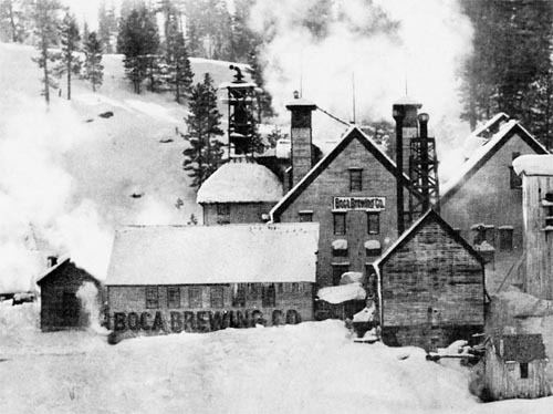
Boca is a former settlement in Nevada County, California. It is situated at an elevation of 5,528 ft (1,685 m) above sea level. Boca is located on the Southern Pacific Railroad, 6.5 miles (10.5 km) northeast of Truckee.
Contents
Map of Boca, CA 96161, USA
History
The place was named by the Central Pacific Railroad Boca (Spanish for "mouth" and "river mouth") in 1867 because it was near the mouth of the Little Truckee River.
It had a post office during the period of 1872 through 1945.
In 1880, the population was 200.
Climate
Boca has a fairly typical climate for its region, a continental Mediterranean climate (Köppen Dsb), with dry summers that feature hot days and cold nights, and cold, snowy winters. Snowfall is less heavy than Truckee and Tahoe City due to the rain shadow effect of the Sierra Nevada, but depths can still reach to 90 inches (2.29 m), and in recent times 70 inches (1.78 m) of snow was on the ground at the end of February 1993.
On January 20, 1937, the temperature at Boca fell to −45 °F (−42.8 °C), the lowest temperature ever recorded in California, though on average only a dozen nights will fall below 0 °F (−17.8 °C) and 256 days exceed 50 °F (10 °C). Nightly frosts are common even in summer, and only 93 nights per year fail to fall below 32 °F (0 °C).