
Parent range Palatine Forest | Elevation 534 m | |
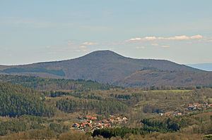 | ||
The Bobenthaler Knopf ("Bobenthal Knob") is a hill, 534 m above sea level, in the southeastern Wasgau, the name given to the region covering the southern part of the Palatine Forest in Germany and the northern part of the Vosges in France.
Map of Bobenthaler Knopf, 76891 Bobenthal, Germany
The hill is located entirely within the territory of the municipality of Bobenthal, from which it derives its name. It lies about two kilometres east of the main settlement. In the west it descends relatively gently to the valley of the Wieslauter stream; in the east it drops considerably more steeply into the valley of the Reisbach. The Bobenthaler Kopf is covered by mixed woods. A footpath leads to the summit from the south. It forms the centre of the 319 hectare Bobenthaler Knopf Core Zone in the Palatine Forest Nature Park. About 1.5 kilometres to the south lie the Rittersteins of Löffelkreuz and Eselsschleifhäuschen.