
Prominence 397 ft (121 m) Elevation 2,163 m | Topo map USGS Boars Tusk Parent range Leucite Hills | |
 | ||
Similar White Mountain, Wilkins Peak, Wind River Range, Gannett Peak | ||
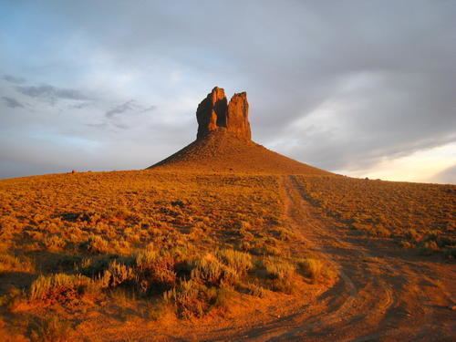
Boars Tusk is an isolated butte within the Rock Springs Uplift in the Green River Basin of southwestern Wyoming. The butte has a peak elevation of 7,101 ft (2,164 m) and rises some 400 ft (120 m) above the surrounding Killpecker Creek plain and lies 26.2 mi (42.2 km) north of Rock Springs. The north end of White Mountain lies 3.0 mi (4.8 km) to the west.
Map of Boars Tusk, Wyoming, USA
Boars Tusk is an isolated remnant of a long extinct volcano associated with the Leucite Hills to the east. Heavily eroded, all that remains of the volcano is part of the erosion resistant volcanic neck which is composed of the uncommon volcanic rock lamproite. Rock samples from Boars Tusk provided an age of 2.5 MA.
References
Boars Tusk Wikipedia(Text) CC BY-SA