
Population 110 (2001 census) Local time Sunday 4:48 PM District Waveney | Sovereign state United Kingdom Postcode district IP19 | |
 | ||
Weather 6°C, Wind SW at 21 km/h, 88% Humidity | ||
Blyford (Blythford) is a village and civil parish in the Waveney district of Suffolk, England, about 3 miles (5 km) east of Halesworth and separated from Wenhaston by the River Blyth, Suffolk to the south. At the 2011 Census the population was included in the civil parish of Sotherton.
Map of Blyford, Halesworth, UK
Not to be confused with
Blyth Haven (south end of the town of Southwold)
Blythburgh, on the same river, further east, halfway between Halesworth and Southwold.
Population in 1801 was 163 and by 1840 had risen to 223. In 1861 the population was 193.
In 1870-72, John Marius Wilson's Imperial Gazetteer of England and Wales described Blyford like this:
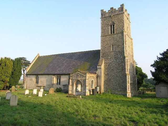
Blyford, formerly Blythford, is a parish in Blything district, Suffolk; on the river Blythe, 2½ miles E by S of Halesworth r. station. Post Town, Halesworth. Acres, 947. Real property, £1,548. Pop., 193. Houses, 41. The living is a donative in the diocese of Norwich. Value, not reported. Patron, the Rev. Jeremy Day. The church, made of mainly flint, has two Norman doors and a perpendicular English tower, but is mainly decorated English.
BBC Radio Suffolk 2010-08-09 reported on the 14th/15th century thatched Queen's Head Inn. The inn sign features St Etheldreda as the Queen. Chickens are located at the inn. The thatched roof was replaced in 1988 after a fire.
The church is just across the road from the inn with rumours of a smugglers passage. The church seats 55 and was built in 1088, with a 13th-century font added.