
Country Sudan Capital Ad-Damazin | Area 45,844 km2 Governor Hussein Yassin Hamad | |
 | ||
Colleges and Universities Blue Nile University, Sinnar University | ||
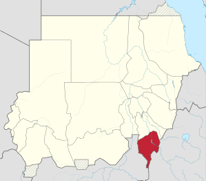
Map of Blue Nile (state)
Blue Nile (Arabic: النيل الأزرق an-Nīl al-ʾAzraq ) is one of the eighteen states of the Republic of Sudan. It was established by presidential decree nº 3 in 1992 and is named after the Blue Nile River. It has an area of 45,844 km² and an estimated population of 1,193,293. The Central Bureau of Statistics quoted the population at 832,112 in the 2006 census. Ad-Damazin is the capital of the state. The state of Blue Nile is home to the Roseires Dam, the main source of hydroelectric power in Sudan until the completion of the Merowe Dam in 2010.
Contents
- Map of Blue Nile state
- Blue nile 2012 documentary film
- Bombing in sudan s blue nile state
- Administration
- References
The region is host to around forty different ethnic groups. Its economic activity is based on agriculture and livestock and increasing mineral exploitation.
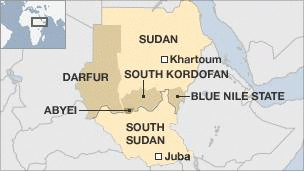
In 2011, residents of Blue Nile were scheduled to hold ill-defined "popular consultations" to determine the constitutional future of the state, per the Comprehensive Peace Agreement. Instead, a dispute over the rightful government of the state, and the determination of Omar al-Bashir to eradicate the Sudan People's Liberation Movement-North, have led to a renewed insurgency and a refugee crisis. It appears that the consultations have been postponed indefinitely.
Blue nile 2012 documentary film
Bombing in sudan s blue nile state
Administration
The State is sub-divided into six districts (with 2006 Census populations shown hereafter):