
Elevation 500 m Local time Saturday 11:27 PM | Area 86.19 km² | |
 | ||
Weather 11°C, Wind S at 21 km/h, 49% Humidity Points of interest Veľká Fatra, Ostrá, Tlstá, Ostredok, Blatnica Castle | ||
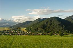
Blatnica (1927–1946 Turčianska Blatnica) is a village and municipality in the Turiec region of Slovakia. Administratively it is a part of the Martin District in the Žilina Region. The village is situated under the Greater Fatra Range, at the opening of the spectacular karst Gader and Blatnica valleys. The ruins of the Blatnica Castle lie on a low ridge over the village.
Contents
Map of 038 15 Blatnica, Slovakia
Etymology
The name means "a muddy place" (Slovak: blato - mud).
History
Blatnica is an important archaeological site, where Slavic tumuli with many precious artifacts (such as the famous Blatnica Sword) from the 8th and 9th centuries have been found. The site gave name to the so-called "Blatnica-Mikulčice" archaeological horizon. The first written mention stems from 1230, however, the castle was built at the end of the 13th century.
Culture
The first Slovak female botanist Izabela Textorisová lived in Blatnica and her rich herbarium contains plants of the nearby Tlstá mountain. Both Textorisová's house and a museum dedicated to the ethnographer, filmmaker, and photographer Karol Plicka are open to the public. Other places of interest include two manor houses from the 18th century, a classicist Lutheran church and many well-preserved rural houses.
Demographics
Blatnica has a population of 881 (as of December 31, 2005). According to the 2001 census, 99% of inhabitants were Slovaks. Blatnica is one of few villages with a Lutheran absolute majority (58.6%) in the predominantly Roman Catholic Slovakia.