
Listing Marilyn, County Top Topo map OS Landranger 197 Prominence 191 m | OS grid SU919296 Elevation 280 m Parent peak Leith Hill | |
 | ||
Location Western Weald, South Downs National Park, England Similar Gibbet Hill - Hindhead, Walbury Hill, Betsom's Hill, Botley Hill, St Boniface Down | ||
Blackdown, or Black Down, is the highest hill in the historic county of Sussex, at 280 metres (919 feet). In southeastern England it is exceeded only by Walbury Hill and Leith Hill.
Contents
- Map of Blackdown Haslemere UK
- LocationEdit
- Natural historyEdit
- HistoryEdit
- Lord TennysonEdit
- Blackdown air crashEdit
- References
Map of Blackdown, Haslemere, UK
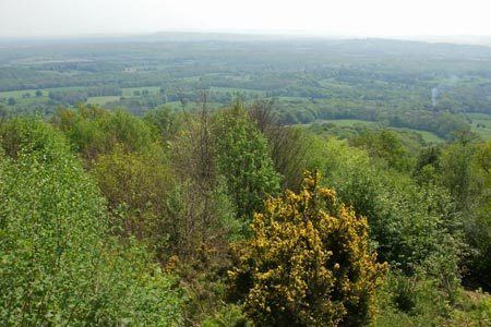
It is also the highest point in the South Downs National Park. The pine- and heather-covered slopes are owned by the National Trust and are a favourite walking spot. Blackdown has strong literary associations with the poet Alfred, Lord Tennyson.
LocationEdit
The great black mass of Blackdown looms over much of the Low Weald of west Sussex and south-west Surrey. Geologically part of the Greensand Ridge and lying on the western margins of the Weald, Blackdown nevertheless lies within the South Downs National Park. It is situated about 1.2 miles (1.9 km) south of Haslemere, and its northern slopes in fact lie within the county of Surrey. There are no villages on Blackdown, but Fernhurst is just to the southwest, and Lurgashall to the southeast.
There are National Trust car parks on Tennyson's Lane, which runs up Haste Hill from Haslemere, and a footpath from the town centre. It is also possible to walk to Blackdown from Lurgashall, although this means walking up the steep southern escarpment. Blackdown is crossed by the Sussex Border Path and the Serpent Trail.
The secluded sunken lane that runs from Haslemere past Aldworth is named Tennyson's Lane in memory of the poet. It is little changed from Arthur Paterson's description in 1905:
Trees meet overhead, copsewood surrounds it, and later, it is hedged by high sandy banks thickly overgrown with plant and scrub; squirrels and rabbits, and all other small woodland creatures, disport themselves over it. It twists and turns, and to the stranger appears to lead nowhere in particular.
Natural historyEdit
The acid sandstone of Blackdown limits the range of plants. Until the beginning of the 20th century, Blackdown was a grazed common where trees were kept down by sheep, and heather dominated. After the end of regular grazing Scots Pine became the dominant species. The National Trust now carries out a programme of tree-felling and controlled burning to maintain and regenerate areas of open heath. The reserve has been fenced so that conservation grazing with cattle can be used as a management tool. Blackdown is an important habitat for insects and birds.
A geological relief model of Blackdown, and much information on its natural history, can be found in the Haslemere Educational Museum.
HistoryEdit
Although common land, Blackdown was the property of various landowners until W. E. Hunter donated it to the National Trust in 1944, as a memorial to his wife. The Hunters are remembered by an inscribed stone seat at the Temple of the Winds. Flint artefacts show there has been settlement on Blackdown since the mesolithic period, around 6000 BC. The name of an ancient track, pen-y-bos, indicates links with the Celtic world long since lost in more accessible parts of south-east England. (The name "pen-y-bos" comes from the Brythonic language of the ancient Britons that lived in the area - rather like the well-known pen-y-ghent in Yorkshire.) Blackdown is managed by the National Trust, with guidance and financial assistance from the Blackdown Committee of the National Trust.
As well as Aldworth House (just visible from the footpath leading down to Roundhurst) and Foxholes (which together formed the estate of Alfred Lord Tennyson), a number of other interesting private houses will be passed by walkers. These include Blackdown House, to the west, surrounded by daffodils in the spring, and Old Manor Farm (previously Upper Roundhurst Farm) on Tennyson's Lane.
Because of its elevation, from 1796 to 1816 Blackdown hosted a station in the shutter telegraph chain which connected the Admiralty in London to its naval ships in Portsmouth.
Lord TennysonEdit
Aside from its height and its wild beauty, Blackdown is best known as the site of the poet's house, Aldworth. Keen to escape the summer 'trippers' who came to his Isle of Wight home, Farringford, Tennyson purchased Blackdown, and built Aldworth in 1869. The French-style Gothic house was designed by Sir James Knowles and is built of local sandstone. It stands on a ridge overlooking the Weald, with magnificent views. Lord Tennyson used Aldworth as his summer residence, taking long walks over Blackdown. He died in the house on 6 October 1892.
Helen Allingham was a frequent visitor to Aldworth in Tennyson's time, and her charming illustrations to The homes of Tennyson vividly capture the landscape of Blackdown.
Blackdown air crashEdit
On Saturday, 4 November 1967, a Caravelle Airliner No. EC-BDD, owned by Iberia Airlines of Spain, crashed; the aircraft was on a scheduled flight from Málaga to Heathrow Airport, and was piloted by Captain Hernando Maura. It broke through a large hedge; parts of the aircraft fell off, destroying a garage and damaging parts of the roof of Upper Black Down House as the aircraft disintegrated. The victims were the all-Spanish crew and the passengers, comprising 25 British, mostly returning from holiday in Spain, two Americans, two Spaniards and two Australians. The British actress June Thorburn was amongst the passengers.