
Counties Sanilac, St. Clair Length 130 km Country United States of America | Basin size 711 sq mi (1,840 km) Mouth St. Clair River | |
 | ||
Main source northern Sanilac County River mouth St. Clair River, Port Huron
574 ft (175 m) | ||
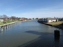
Black River is an 81.0-mile-long (130.4 km) river in the U.S. state of Michigan, flowing into the St. Clair River in the city of Port Huron. The Black River Canal in northern Port Huron extends east into Lake Huron near Krafft Road.
Contents
- Map of Black River Minden Township MI USA
- Main stream from the mouth to Mill Creek
- Mill Creek
- North Branch Mill Creek
- South Branch Mill Creek
- Main stream from Mill Creek to Black Creek
- Black Creek
- Main stream from Black Creek to Elk Creek
- Elk Creek
- Main stream above Elk Creek
- Lapeer County
- St Clair County
- Sanilac County
- References
Map of Black River, Minden Township, MI, USA
The river rises in northern Sanilac County, near the boundary with Huron County, and its 711-square-mile (1,840 km2) drainage basin covers most of the central and southern portions of Sanilac County, most of northern St. Clair County, and portions of east central Lapeer County. Large sections of the upper portion of the river and much of its drainage basin are heavily channelized for agricultural irrigation. Black River was the original name of the city of Croswell at the time of its founding in 1845.
Main stream from the mouth to Mill Creek
Mill Creek
North Branch Mill Creek
Elk Lake Creek
South Branch Mill Creek
Main stream from Mill Creek to Black Creek
Black Creek
Main stream from Black Creek to Elk Creek
Elk Creek
Main stream above Elk Creek
Lapeer County
St. Clair County
Sanilac County
References
Black River (St. Clair County) Wikipedia(Text) CC BY-SA