
Main source Teletskoye Lake Length 301 km Basin area 37,000 km² Country Russia | River mouth Ob River Discharge 477 m³/s Mouth Ob River | |
 | ||
Basin size 37,000 km (14,000 sq mi) | ||
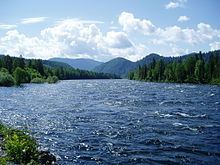
The Biya River (Russian: Бия) is a river in the Altai Republic and Altai Krai in Russia. It forms the Ob River as it joins the Katun River. The Biya River is 301 km long; the area of its drainage basin is 37,000 km2. It flows out of the Teletskoye Lake. The river freezes up during the mid-November to early December (some parts of the river freeze over on a year-to-year basis). It breaks up in the early or mid-April. The Biya River is navigable up to the town of Biysk.
Map of Biya River, Russia
The maximum depth of river is 28 feet (8.5 m).
References
Biya River Wikipedia(Text) CC BY-SA