
Elevation 2,782 m | ||
 | ||
Similar Pollock Mountain, Piegan Mountain, Allen Mountain, Mount Gould, Grizzly Mountain | ||
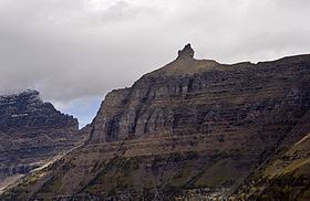
Bishops Cap (9,127 feet (2,782 m)) is located in the Lewis Range, Glacier National Park in the U.S. state of Montana. Located above the Garden Wall and straddling the Continental Divide, when viewed from the south at Logan Pass, the peak appears to resemble a Bishop's headwear. The name Bishops Cap is descriptive only, and there's no known origin.
Map of Bishops Cap, Montana 59417, USA
References
Bishops Cap Wikipedia(Text) CC BY-SA