
Country Germany Admin. region Unterfranken Time zone CET/CEST (UTC+1/+2) Population 4,887 (31 Dec 2008) | State Bavaria District Rhön-Grabfeld Postal codes 97653 Local time Thursday 7:06 PM | |
 | ||
Weather 6°C, Wind SW at 31 km/h, 60% Humidity Points of interest Kloster Kreuzberg, Kreuzberg, Arnsberg, Arnsberg ‑ Lift, Ruine Osterburg | ||
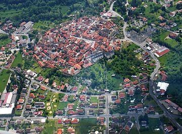
Bischofsheim an der Rhön is a town in the district Rhön-Grabfeld, in Bavaria, Germany. It is situated in the Rhön Mountains, 29 km southeast of Fulda.
Contents
- Map of 97653 Bischofsheim an der RhC3B6n Germany
- Town Structure
- History
- Sights
- Born in Bischofsheim
- References
Map of 97653 Bischofsheim an der Rh%C3%B6n, Germany
Town Structure
Several originally separate villages became part of the town Bischofsheim. These are Frankenheim, Haselbach, Oberweißenbrunn, Unterweißenbrunn and Wegfurt.
History
In a document of the early 13th century Bischofsheim was first mentioned. The town is much older, probably 8th century. The name Bischofsheim (German: home of the bishop) indicates that the town was maybe founded by Saint Boniface. As Bischofsheim is situated between Fulda and the palatinate Salz, Boniface founded a settlement to rest on the way.
Sights
Born in Bischofsheim
References
Bischofsheim an der Rhön Wikipedia(Text) CC BY-SA