
1945–1975 →
→
→ Established 1945 Political subdivisions 24 counties (powiaty) | Capital Białystok Disestablished 1975 Area 23,154 km² | |
 | ||
See also: Białystok Voivodeship (1919–39) and Białystok Voivodeship (1975–1998)
Contents
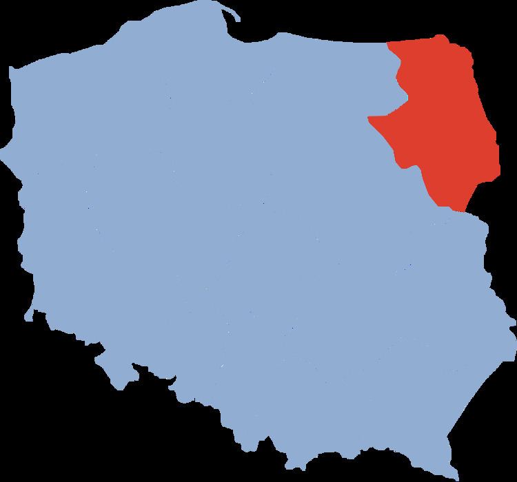
Białystok Voivodeship (Polish: Województwo białostockie) was a unit of administrative division and local government in Poland from 1945 to 1975, when its purview was separated into eastern Suwałki Voivodeship, Łomża Voivodeship and Białystok Voivodeship (1975-1998). Its capital city was Białystok. The establishment of Podlaskie Voivodeship in 1999 was essentially a reunion of the areas of Białystok Voivodeship (1945-1975).
Area administrative region of 1950, amounted to 23 201 square kilometers, was later reduced to 23 153 square kilometers. The population was in 1946, approximately 941 000, in 1970 approximately 1 176 000 inhabitants.
History
In early 1944, when the Red Army crossed the Polish frontier before the war, the Bialystok Voivodeship was divided administratively by the German occupied areas incorporated into the Third Reich (Bezirk Bialystok) and the occupied territories of the USSR (Reich Commissariat East).
Over the next months, the front was moving into the pre-war Polish territory. However, according to the findings of the Tehran Conference of 1943 it was known that the pre-war Polish eastern territories will be incorporated into the Soviet Union and eastern territories of Germany will be incorporated into Polish (more precisely define these territorial changes occurred during the Yalta Conference and the Potsdam Conference ). For this reason, the Polish territories occupied by the Red Army in early 1944 did not create the Polish administration. Only after crossing the line in July 1944 the Bug, which is the future eastern border of Polish, Polish authorities have been established in the form of the Polish Committee of National Liberation (PCNL) .
A month after the start of its operations PCNL issued Decree of the Polish Committee of National Liberation of August 21, 1944 on the Procedure for the appointment of general administration authorities and second instance, which came into force on 22 August 1944. In this decree (Article 11) abolished the administrative structure introduced by Germany and restored the Bialystok Voivodeship administrative divisions during the Second Polish Republic. At the time, ran on the front line of the Vistula and Narew, and the formal authority PKWN had was only part of the pre-war Bialystok Voivodeship.
29 September 1944, administration of 17 (of the 23) districts of Belastok Region (including the city of Białystok) and an additional three (Siemiatycze, Hajnówka and Kleszczele) of the Brest Region was passed to the Polish Committee of National Liberation from the BSSR.
31 December 1944 the Provisional Government of the Polish Republic replaced the Polish Committee of National Liberation.
14 March 1945 the Provisional Government of the Republic of Polish made the initial administrative division of the German lands included in the Polish (so-called Recovered Territories ), even before taking all of these areas, creating them four administrative districts do not have the status of regions: Region I (Opole Silesia), District II (Lower Silesia), District III (West Pomerania), District IV (Mazury).
The Border Agreement between Poland and the USSR of 16 August 1945 established the borders between the Union of Soviet Socialist Republics (USSR) and the Republic of Poland. It was signed by the Provisional Government of National Unity (Polish: Tymczasowy Rząd Jedności Narodowej).
August 18, 1945 transferred Lomza County from the Warsaw Voivodeship to the Białystok Voivodeship.
September 25, 1945 part of the counties of the Recovered Territories transmitted under the management of the Białystok Voivodeship (Gołdap, Ełk and Olecko) from District IV (Mazury). These districts have provisionally become parts of the Voivodeship, although de jure continue to form part of Recovered Territories (MP, 1945 No. 29, item. 77). On June 28, 1946, the areas of the Recovered Territories assigned to Białystok Voivodeship were formally transferred.
Some cities lost civic rights without joining larger neighboring cities: Dąbrowa Białostocka*, Kleszczele*, Krynki, Sokoły, Suchowola*, Tykocin* (1950)
1 July 1952 created Siemiatycze County.
1954 the following Counties were created: hajnowski, łapy, moniecki, zambrow
Between 1954 and 1972, gromadas formed the lowest tier of local government in the voivodeship, taking over the role previously played by gminy. A gromada would generally consist of several villages, but they were smaller units than the gminy had been. In 1973 gminy were reintroduced and gromadas abolished.
1956 the following counties were created: dąbrowski (białostocki), sejneński
Województwo białostockie
List of Counties in 1967:
Adjacent voivodeships
The Voivodeship shares a border on the east with the Olsztyn Voivodeship, the southwest with the Warsaw Voivodeship, the south with the Lublin Voivodeship, the north with the RSFSR's Kaliningrad Oblast, the northeast with the Lithuanian SSR and the east with the Byelorussian SSR.