
Elevation 15 m (49 ft) Population 18,233 (2014) | Judicial district Castelló de la Plana | |
 | ||
Demonym(s) Benicassut, benicassuda Weather 11°C, Wind N at 2 km/h, 86% Humidity Points of interest Torre de San Vicente, Platja els Terrers, Ruta de las Villas (el "Biarritz v, Castillo de Bezmiliana | ||
Benicàssim ([beniˈkasim], Spanish: Benicasim, Arabic: بنو قاسم according to numismatic findings) is a municipality and beach resort located in the province of Castelló, on the Costa del Azahar in Spain. The Desert de les Palmes mountain range further inland shelters the town from the north wind. The name is derived from the Banu Qasim tribe, a segment of the Kutama Berbers that settled the area during the 8th century Moorish conquest of Spain.
Contents
- Map of 12560 BenicC3A0ssim CastellC3B3n Spain
- Beaches
- Desierto de las Palmas
- Festivals
- Va Verde
- References
Map of 12560 Benic%C3%A0ssim, Castell%C3%B3n, Spain
Benicassim is located 13 km north of the town of Castelló de la Plana, at the north end of the Valencian Community. The town has a population of 18,098. Its economy is largely based on tourism; the town is well known for its beaches and its music festivals such as Festival Internacional de Benicàssim (FIB) and the Rototom Sunsplash.
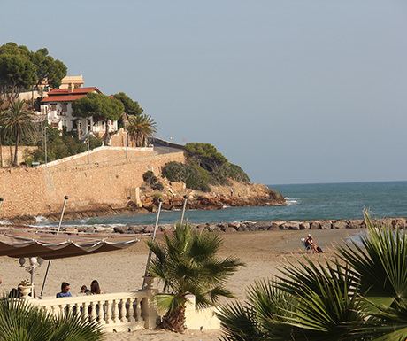
Beaches
Benicassim has 6 kilometers of sandy beaches linked by a promenade. The five beaches in this stretch of coast are named
The beaches have been awarded the Blue Flag quality certification since 1987.
Desierto de las Palmas
Benicassim is next to the "Desert de les Palmes" mountains whose highest peak is Mount Bartolo at 729 meters. The Columbretes Islands are usually visible from the summit of the mountain.
Festivals
Vía Verde
The ”Vía Verde” (green way) is a 5.5 km long cycle path along the rugged coast between the resort towns of Benicassim and Oropesa.