
Prominence 379 m (1,243 ft) Parent peak Feldberg Parent range Black Forest Phone +49 7673 888280 | Isolation 13.5 km (8.4 mi) Location Germany Elevation 1,414 m Mountain range Black Forest | |
 | ||
Address Obermulten 5, 79677 Aitern, Germany Hours Open today · 9:15AM–4:30PMThursday9:15AM–4:30PMFriday9:15AM–4:30PMSaturday9:15AM–4:30PMSunday9:15AM–4:30PMMonday9:15AM–4:30PMTuesday9:15AM–4:30PMWednesday9:15AM–4:30PM Similar Schauinsland, Feldberg, Herzogenhorn, Blauen, Kandel | ||
The Belchen, 1,414 metres (4,639 ft), or Black Forest Belchen (German: Schwarzwälder Belchen) is the fourth highest summit of the Black Forest after the Feldberg, Seebuck and the Herzogenhorn. The municipalities of Münstertal, Schönenberg and Kleines Wiesental meet on the summit dome of the Belchen which is located in the southwest German state of Baden-Württemberg.
Contents
DescriptionEdit
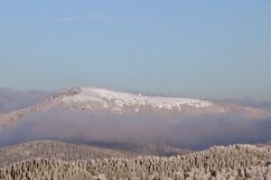
The domed, treeless summit has a striking profile that, seen from the Upper Rhine Plain, is almost symmetrical. Belchen (Celtic: the radiant) is a name also used for other high points in the neighbouring mountains, including two that are especially striking when covered with snow. Together with the Black Forest Belchen, they form the so-called Belchen Triangle: to the west on the French side of the Upper Rhine Plain is the Alsatian Belchen (Elsässer Belchen) or Ballon d'Alsace in the Vosges; to the south on the southern side of the Upper Rhine is the Swiss Belchen (Schweizer Belchen), the Belchenflue. In addition, within sight in the Alsace in the Vosges are the Great Belchen (Großer) and Little Belchen (Kleiner Belchen), or Grand and Petit Ballon which, together with the others belong to the so-called Belchen System.
The panorama from the top covers large parts of the Black Forest to the Hornisgrinde, the Vosges, the Jura and, in good weather, the Alps from the Zugspitze to Mont Blanc. The Belchen also has far-reaching views across the Upper Rhine Plain to Alsace.
GeographyEdit
The Belchen, with its furrowed, unbroken rock faces, rises 1,000 metres out of the Münstertal valley. Its north face is thus the area of highest relief energy in the German Central Uplands. Even towards the south the mountain drops steeply, its schrofen slopes descending 800 metres into the valley bowl of the Little Wiese near Neuenweg.
The large expanse of rolling plateau in the eastern Black Forest has only survived in small places at the Belchen. Towards the Rhine Plain and the mountain of Blauen the western main crest of the Southern Black Forest has been cut into narrow ridges as a result of the marked uplift of the range during the Pleistocene and the erosive work of its streams. The ice age glaciation of the Belchen region has not left such clear traces behind as those on the Feldberg. To the north and south, small avalanche bowl glaciers formed, whose maximum extent reached the edge of the Black Forest.
The domed kuppe consists of granite, whereas the surrounding mountainsides are mostly formed of gneisses. The area around the Belchen was a mining region, at times an important one, between 900 and 1975.
A chain of well-preserved boundary stones from 1790 runs over the summit of the Belchen. These mark the old border between the Habsburg territory of Further Austria to the north and the Margraviate of Baden to the south of the mountain.
Belchen Nature ReserveEdit
Because of its rare flora and fauna, Belchen was declared a nature reserve in 1949. The area was extended to 1600 ha in 1993. and is now one of the largest nature reserves in Baden-Württemberg.
Many species of rare butterfly, beetle and bird are found in the highland areas of the Belchen. Typical birds include the raven, song thrush, citril finch and water pipit, but peregrine, capercaillie and hazel grouse are also found on the Belchen.
Among the plants are relicts from the last ice age that are otherwise only found in the Alps. These include the Swiss bellflower, Alpine rose, Swiss hawkbit and lichens.
TourismEdit
With more than 300,000 visitors a year the Belchen is one of the most popular destinations in the Southern Black Forest.
In 1866 the first guest house was built below the summit. In 1899 its replacement was finished. This has been expanded and remodelled several times. In 1904 the road to the Belchen was opened. In 1949 the proposal to build a chair lift from Obermünstertal to the summit failed. Ski slopes are limited although there are now eleven ski lifts in the Belchen region. The Belchen road was the public road with the highest destination in the German Central Uplands. The uppermost section has been placed out of bounds since the opening of the cable car in December 2001.
The Belchen lies on the West Way, a long distance path maintained by the Black Forest Club, which runs from Pforzheim to Basle. Other marked footpaths run from Untermünstertal, Schönau and Neuenweg up the mountain.
In 2008, in order to protect the valuable nature conservation area, for visitor management and as a development concept the so-called Belchen concept was developed and submitted as a model. It formulated aims, recommendations and spheres of action, not just for institutions and authorities, but also for the local population and guests. Participants included the Forestry Test and Research Centre for Baden-Württemberg in Freiburg, the German Sport University, Cologne, the Southern Black Forest Nature Park, the municipality of Münstertal, the Münstertal-Staufen Holiday Region and private citizens of Münstertal.
Belchen Gondola LiftEdit
The Belchen Gondola Lift operates as a single-cable lift with 8-man cabins or gondolas from the bottom station in Aitern-Multen (GVV Schönau) to the top station at 1,356 metres above sea level. It is 1,150 metres long and climbs through 262 metres. Its theoretical capacity is 1,200 passengers per hour. The cabins are of the Leitner CA 8-2000 type and were originally made for the cable car at Expo 2000 in Hanover. The Belchenbahn has disabled boarding and alighting facilities at the top and bottom stations.
The cable is loaded daily with 23 coupled gondolas (plus 2 reserve cabins) from the gondola garage in the direction of travel, they are re-garaged on the return journey and the whole operation is fully automatic. Operating speeds are controllable within a range from 0.3 m/s to 5.0 m/s. The highest of the eight pylons of the lift is 18.6 metres high. The power output os 340 kW. The carrying cable has a diameter of 46 mm. The lift has 108 rollers on the working part of the route.