
Location Haifa District, Israel Type Cultural Address Kiryat Tiv'on, Israel | Nearest city Haifa Criteria ii, iii Phone +972 4-983-1643 | |
 | ||
Governing body Israel Nature and Parks Authority Official name Necropolis of Beit She'arim: A Landmark of Jewish Renewal Management Israel Nature and Parks Authority Similar Nahal Taninim, Gan HaShlosha National, Nahal Ayun, Mount Arbel, Bar'am Forest | ||
Beit she arim national park israel the cave of coffins dozens of rock sarcophagus
Beit She'arim (Hebrew: בֵּית שְׁעָרִים, "House of the Gates") is the currently used name for the ancient Jewish town of Bet She'arāyim (Hebrew: בּית שערַיִם, "House of Two Gates") or Kfar She'arāyim (Hebrew: כְּפר שערַיִם, "Village of Two Gates"). The Arabic name of the hill it stands on is Sheikh Ibreik or Sheikh Abreik. Another Arabic name is bayt al-ġurabāʾ (بيت الغرباء).
Contents
- Beit she arim national park israel the cave of coffins dozens of rock sarcophagus
- Beit she arim national park
- NameEdit
- Iron AgeEdit
- Second Temple periodEdit
- Roman and Byzantine periodsEdit
- Early Islamic periodEdit
- Crusader periodEdit
- Ottoman periodEdit
- British MandateEdit
- ArchaeologyEdit
- Jewish necropolisEdit
- Cave of Judah the PrinceEdit
- Himyarite tombsEdit
- Glassmaking industryEdit
- Poem inside catacombEdit
- Recent excavationsEdit
- References
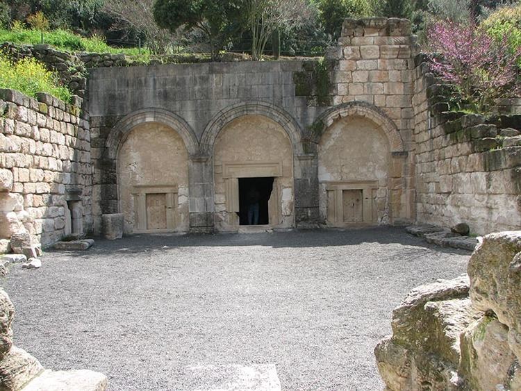
The partially excavated archaeological site consists mainly of an extensive necropolis of rock-cut tombs and some remains of the town itself. The site is managed by the National Parks Authority as the Beit She'arim National Park. It borders the town of Kiryat Tiv'on on the northeast and is located five kilometres west of Moshav Beit She'arim. It is situated 20 km east of Haifa in the southern foothills of the Lower Galilee.
In 2015 it was declared a UNESCO World Heritage Site. The rationale of the committee was as follows: The town's vast necropolis, carved out of soft limestone, contains more than 30 burial cave systems. Although only a portion of the necropolis has been excavated, it has been likened to a book inscribed in stone. Its catacombs, mausoleums, and sarcophagi are adorned with elaborate symbols and figures as well as an impressive quantity of incised and painted inscriptions in Hebrew, Aramaic, Palmyrene, and Greek, documenting two centuries of historical and cultural achievement. The wealth of artistic adornments contained in this, the most ancient extensive Jewish cemetery in the world, is unparalleled anywhere.
Beit she arim national park
NameEdit
According to Moshe Sharon, following Yechezkel Kutscher, the name of the city was Bet She'arayim or Kfar She'arayim (the House/Village of Two Gates). The ancient Yemenite Jewish pronunciation of the name is also "Bet She'arayim", which is more closely related to the Ancient Greek rendition of the name, i.e. Βησάρα, "Besara".
The popular orthography for the Hebrew word for house, בֵּית, is "beit", while the traditional King James one is "beth", the effort being now to replace both with the etymologically better suited "bet".
Iron AgeEdit
Pottery shards discovered at the site indicate that a first settlement there dates back to the Iron Age.
Second Temple periodEdit
Beit She'arayim was founded at the end of the 1st century BCE, during the reign of King Herod. The Roman Jewish historian Josephus Flavius, in his Vita, referred to the city in Greek as Besara, the administrative center of the estates of Queen Berenice in the Jezreel Valley.
Roman and Byzantine periodsEdit
Benjamin Mazar described it as a prosperous Jewish town eventually destroyed by fire in 352, at the end of the Jewish revolt against Gallus and that after some time it was renewed as a Byzantine city, but more recent research shows that the Gallus revolt had a much lesser impact on the town. The Galilee earthquake of 363 did damage Bet She'arayim, but without long-lasting effects.
After the destruction of the Second Temple in 70 CE, the Sanhedrin (Jewish legislature and supreme council) moved to Beit She'arayim. The town is mentioned rabbinical literature as an important center of Jewish learning during the 2nd century. Rabbi Judah the Prince (Yehudah HaNasi), head of the Sanhedrin and compiler of the Mishna, lived there. In the last seventeen years of his life, he moved to Sepphoris for health reasons, but planned his burial in Beit She'arim. According to tradition, he owned there land he received as a gift from his friend, the Roman emperor Marcus Aurelius Antoninus. The most desired burial place for Jews was the Mount of Olives in Jerusalem, but in 135 CE, when Jews were barred from the area, Beit She'arim became an alternative. The fact that Rabby Judah was buried there led many other Jews from all over the country and from the Jewish Diaspora, from nearby Phoenicia to far-away Himyar in Yemen, to be buried next to his grave.
While it was originally thought that Bet She'arayim was destroyed during the Jewish revolt against Gallus in the mid-4th century, recent research has revealed the destruction to be far less extensive. An earthquake in 386 caused some damage, but the town recovered and enjoyed prosperity during the era of Byzantine rule. Almost 300 inscriptions primarily in Greek, but also in Hebrew, Aramaic, and Palmyrene were found on the walls of the catacombs containing numerous sarcophagi.
Early Islamic periodEdit
From the beginning of the Early Islamic period (7th century), settlement was sparse. Excavations uncovered 75 lamps dating to the period of Umayyad (7th-8th centuries) and Abassid (8th-13th centuries) rule over Palestine. A large Abbasid-period glassmaking facility from the 9th century was also found at the site (see below).
Crusader periodEdit
There is some evidence of activity in the former city area and necropolis dating to the Crusader period (12th century), probably connected to travellers and temporary settlement.
Ottoman periodEdit
A small Arab village called Sheikh Bureik was located here in the late 16th century. A map by Pierre Jacotin from Napoleon's invasion of 1799 showed the place, named as Cheik Abrit.
The village is mentioned again in The Survey of Western Palestine (SWP) citing data from 1859, and in 1875 by Victor Guérin. In 1872, the Ottoman authorities sold Shayk Abreik (together with a total of 23 villages and some seventy square miles of land) for £20,000 to the Sursuk family of Lebanon. "The Survey of Western Palestine", published in 1881, describes Sheikh Abreik as a small village situated on a hill with a conspicuous maqam (sanctuary, holy tomb) located to the south. The village houses were made mostly of mud, and it belonged to the Sursuk family. The population at this time was estimated to be around 150. During World War I, the "finest oaks" of Sheikh Bureik were "ruthlessly destroyed" by the Turkish Army for use as rail fuel.
British MandateEdit
The October 1922 census of Palestine recorded Sheikh Abreik with a population of 111 Muslims. At some time during the early 1920s, the Sursuk family sold the lands of the village to the Jewish National Fund, via Yehoshua Hankin, a Zionist activist who was responsible for most of the major land purchases of the World Zionist Organization in Ottoman Palestine. After the sale, which included lands from the Arab villages of Harithiya, Sheikh Abreik and Harbaj, a total of 59 Arab tenants were evicted from the three villages, with 3,314 pounds compensation paid. In 1925 an agricultural settlement also named Sheikh Abreik was established by the Hapoel HaMizrachi, a Zionist political party and settlement movement.
ArchaeologyEdit
The archaeological importance of the site was recognized in the 1880s by the Survey of Western Palestine, which explored many tombs and catacombs but did no excavation. The Arab Palestinian village of Sheikh Bureik was located on the hill until the 1920s, when the land was purchased by the Jewish National Fund. In 1936, Alexander Zaïd, employed by the JNF as a watchman, reported that he had found a breach in the wall of one of the caves which led into another cave decorated with inscriptions. In the 1930s and 1950s, the site was excavated by Benjamin Mazar and Nahman Avigad.
Jewish necropolisEdit
Most of the remains date from the 2nd to 4th century CE. A large number of individuals were buried in the more than twenty catacombs of the necropolis. Geographical references in inscriptions on the walls of the catacombs reveal that the necropolis was used by people from the town of Beit She'arim, from elsewhere in Galilee, and even from cities as far away as Palmyra and Tyre.
Aside from an extensive body of inscriptions in several languages, the walls and tombs have many images, engraved and carved in relief, ranging from Jewish symbols and geometric decoration to animals and figures from Hellenistic myth and religion.
In October 2009, two new caves were opened to the public whose burial vaults date to the first two centuries CE.
Cave of Judah the PrinceEdit
The Jerusalem Talmud cites Beit She'arim as the burial place of Rabbi Judah the Prince, Yehuda HaNasi in Hebrew. His funeral is described as follows: "Miracles were wrought on that day. It was evening and all the towns gathered to mourn him, and eighteen synagogues praised him and bore him to Bet Shearim, and the daylight remained until everyone reached his home (Ketubot 12, 35a)." The fact that Rabbi Judah was buried here is believed to be a major reason for the popularity of the necropolis in Late Antiquity. The catacomb No. 14 is likely to have belonged to the family of Rabbi Judah the Prince. A clear inscription stating the name and title of Rabbi Judah the Prince in that catacomb identifies it as his burial site. A Hebrew wall inscription from Catacomb 14 reads "Simon [Shimon] my son shall be hakham [president of the Sanhedrin], Gamaliel my son patriarch, Hanania bar Hama shall preside over the great court", in reference to Rabbi Judah's sons Rabbi Shimon and Rabbi Gamliel, and to his student, Rabbi Hanina bar Hama. Two tombs located next to each other within the same catacomb are identified by bilingual Hebrew and Greek inscriptions as those of "R. Gamliel" and "R. Shimon", believed to refer to Judah's sons, the nasi Gamaliel III and the hakham Rabbi Shimon.
Himyarite tombsEdit
In 1937, Benjamin Mazar revealed at Beit She'arim a system of tombs belonging to the Jews of Himyar (now Yemen) dating back to the 3rd century CE. The strength of ties between Yemenite Jewry and the Land of Israel can be learnt, of course, by the system of tombs at Beit She'arim dating back to the 3rd century. It is of great significance that Jews from Ḥimyar were being brought for interment in what was then considered a prestigious place, near the catacombs of the Sanhedrin. Those who had the financial means brought their dead to be buried in the Land of Israel, as it was considered an outstanding virtue for Jews not to be buried in foreign lands, but rather in the land of their forefathers. It is speculated that the Ḥimyarites, during their lifetime, were known and respected in the eyes of those who dwelt in the Land of Israel, seeing that one of them, whose name was Menaḥem, was coined the epithet qyl ḥmyr [prince of Ḥimyar], in the eight-character Ḥimyari ligature, while in the Greek inscription he was called Menae presbyteros (Menaḥem, the community's elder). It is interesting to note that the name of a woman in Greek letters, in its genitive form, Ενλογιαζ, was also engraved there, meaning either 'virtue', 'blessing', or 'gratis'.
Glassmaking industryEdit
In 1956, a bulldozer working at the site unearthed an enormous rectangular slab, 11×6.5×1.5 feet, weighing 9 tons. Initially, it was paved over, but it was eventually studied and found to be a gigantic piece of glass. A glassmaking furnace was located here in the 9th century during the Abbasid period, which produced great batches of molten glass that were cooled and later broken into small pieces for crafting glass vessels.
Poem inside catacombEdit
An elegy written in Arabic script typical of the 9-10th century and containing the date AH 287 or 289 (AD 900 or 902) was found in the Magharat al-Jahannam ("Cave of Hell") catacomb during excavations conducted there in 1956. The sophisticated and beautifully worded elegy was composed by the previously unknown poet Umm al-Qasim, whose name is given in acrostic in the poem, and it can be read in Moshe Sharon's book or here on Wikipedia.
Moshe Sharon speculates that this poem might be marking the beginning of the practice of treating this site as the sanctuary of Sheikh Ibreik and suggests the site was used for burial at this time and possibly later as well. He further notes that the cave within which the inscription was found forms part of a vast area of ancient ruins which constituted a natural place for the emergence of a local shrine. Drawing on the work of Tawfiq Canaan, Sharon cites his observation that 32% of the sacred sites he visited in Palestine were located in the vicinity of ancient ruins.
Recent excavationsEdit
The excavations at the site were resumed by Adi Erlich, on behalf of the Zinman Institute of Archaeology, The University of Haifa. Erlich is focusing her excavation on the hilltop above the necropolis, where the ancient town had existed.