
Topo map OS Landranger 36 Prominence 456 m Parent peak Ben Macdui | OS grid NJ092006 Elevation 1,196 m Parent range Cairngorms | |
 | ||
Translation Mountain of the table (Gaelic) Pronunciation Scottish Gaelic: [ˈpeiɲ ə ˈvuːrˠtʲ] Similar Ben Avon, Ben Macdui, Beinn a' Chaorainn, Beinn Mheadhoin, Beinn Bhreac | ||
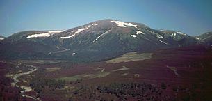
Beinn a' Bhùird is a Munro in the Cairngorm mountain range of Scotland.
Contents
Map of Beinn a' Bh%C3%B9ird, Ballater, UK
In Watson (1975) the author suggests the mountain should be named Beinn Bòrd - table hill, saying that local Scottish Gaelic speakers pronounced the mountain Paing Bòrd, with some of the older local folk still using Painna Bòrd.
The closest 'village' to Beinn a' Bhùird is Braemar, Aberdeenshire and the most common approach by car is through this village. To reach Beinn a' Bhùird by car, the most common approach is by the Linn of Dee road along the south side of the River Dee to the Linn of Dee, looping back along the north-bank to the car park at Allanaquoich where camping is permitted. The distance between Braemar and Allanaquoich by this route is about 10 miles.
In 2006 a glider pilot from Deeside Gliding Club crashed on the hillside, spending 24 hours trapped in his plane before he was located by the RAF.
Ascents
The usual ascent of Beinn a' Bhùird is from the car park at Allanaquoich walking up Glen Quoich and following the new path along the line of the old land rover road up An Diollaid.
An alternate ascent follows the Quoich Water through the Am Beitheachan to the bealach named The Sneck (Watson, 1975) (and the 1:25000 series Ordnance Survey maps) - between Beinn a' Bhùird and Ben Avon.
Skiing
In the early 1960s there was an attempt to develop a large ski area on Beinn a' Bhùird. The development was financed by the Panchaud brothers (Gerald and Jhon) of Switzerland who had purchased the estate when skiing in Scotland was booming. The area was to be called Mar Lodge and opened in 1963 after a series of record snowfalls. At the time of opening there were two T-bars on site, one 620 ft long and one 2050 ft long. These offered a total uphill capacity of 1,400 people per hour. Unfortunately, the seasons of 1963-64 and 1964-65 offered very little snow to the area, meaning that the ski lifts were rarely used, with the resort becoming abandoned in 1965. When the resort closed both T-bars were moved to Glenshee to become the Cairnwell T-Bar and Trainer Tow (removed for the 2003 season).