
Country United States of America | ||
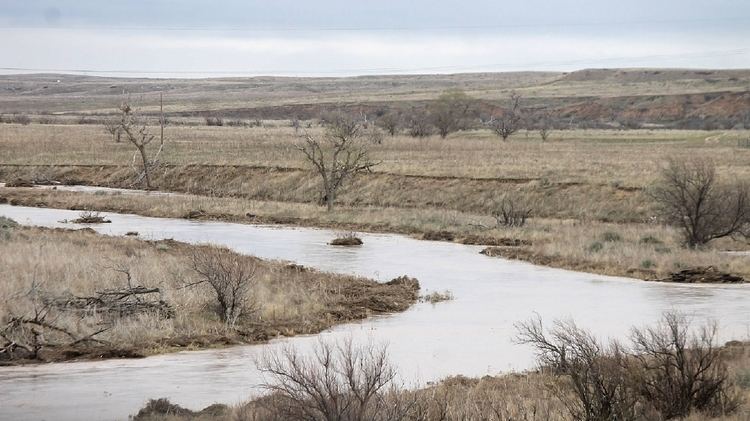 | ||
The Beaver River is the historic name for an intermittent river in Oklahoma that drains most of the Oklahoma Panhandle. It is also known as the North Canadian River; both names are in common use. The Beaver River flows from Union County, New Mexico, entering the Oklahoma Panhandle in Cimarron County, then flowing out of state through Sherman County in the Texas Panhandle for about 15 miles (24 km), then back to the Oklahoma panhandle in Texas County, where it is impounded in Optima Lake. Downstream of the dam, it continues through the Oklahoma counties of Beaver and Harper before ending in Woodward County.
Contents
Map of Beaver River, Oklahoma, USA
CourseEdit
The antecedent of the Beaver River is Corrumpa Creek, which has a north branch and a south branch both originating from the slopes of Sierra Grande volcano southwest of the town of Des Moines, New Mexico, then converging downstream at Weatherly Lake, a reservoir in Union County, New Mexico.
After the New Mexico/Oklahoma border, Corrumpa Creek is joined by Cienequilla Creek (also known as Seneca Creek) 4.5 miles (7.2 km) northwest of Felt, Oklahoma, after which it begins as the Beaver River. The name arbitrarily changes downstream, the USGS topographic maps mark the stream either "Beaver River" or "North Canadian River". At Fort Supply in Woodward County, Oklahoma, Beaver River ends at its confluence with Wolf Creek after which it continues further as the North Canadian River.
TributariesEdit
Some of the major tributaries of Beaver River are (from West to East):
- Cienequilla Creek (36.597247°N 102.867422°W / 36.597247; -102.867422 (Cienequilla Creek))
- Sand Creek (36.597525°N 101.769329°W / 36.597525; -101.769329 (Sand Creek))
- Tepee Creek (36.691692°N 101.681828°W / 36.691692; -101.681828 (Tepee Reiver))
- Goff Creek (36.725859°N 101.471827°W / 36.725859; -101.471827 (Golf Creek))
- Pony Creek (36.718637°N 101.270438°W / 36.718637; -101.270438 (Pony Creek))
- Coldwater Creek (36.659749°N 101.121271°W / 36.659749; -101.121271 (Coldwater Creek))
- Palo Duro Creek (36.655583°N 100.964881°W / 36.655583; -100.964881 (Palo Duro Creek))
- Red Horse Creek (36.695026°N 100.916269°W / 36.695026; -100.916269 (Red Horse Creek))
- Bull Creek (36.694471°N 100.915992°W / 36.694471; -100.915992 (Bull Creek))
- Jackson Creek (36.788081°N 100.812936°W / 36.788081; -100.812936 (Jackson Creek))
- Sharp Creek (36.797525°N 100.806825°W / 36.797525; -100.806825 (Sharp Creek))
- Willow Creek (36.818081°N 100.713489°W / 36.818081; -100.713489 (Willow Creek))
- Elm Creek (36.818081°N 100.667098°W / 36.818081; -100.667098 (Elm Creek))
- Dugout Creek (36.819748°N 100.626264°W / 36.819748; -100.626264 (Dugout Canoe))
- Home Creek (36.823359°N 100.534872°W / 36.823359; -100.534872 (Home Creek))
- Timber Creek (36.821694°N 100.394312°W / 36.821694; -100.394312 (Timber Creek))
- Camp Creek (36.787250°N 100.351533°W / 36.787250; -100.351533 (Camp Creek))
- Kidds Creek (36.776141°N 100.225418°W / 36.776141; -100.225418 (Kidds Creek))
- Mexico Creek (36.765308°N 100.191806°W / 36.765308; -100.191806 (Mexico Creek))
- Kiowa Creek (36.758921°N 99.905685°W / 36.758921; -99.905685 (Kiowa Creek))
- Spring Creek (36.684478°N 99.855126°W / 36.684478; -99.855126 (Spring Creek))
- Clear Creek (36.648923°N 99.7679°W / 36.648923; -99.7679 (Clear Creek))
- Wolf Creek (36.588924°N 99.501779°W / 36.588924; -99.501779 (Wolf Creek))
FlowEdit
The Beaver River and its tributaries flow with water intermittently. In part, this is because the underground source of river, the Ogallala Aquifer, being the water table beneath far western Oklahoma and parts of seven other Western states as well, has been subject to depletion in recent decades due to increased irrigation and drinking water withdrawals. A few short stretches, such as McNees Crossing (one mile east of State Road 406), have persistent flow. The remainder flows under the sand except after rain falls or snow melts. The area drained by the Beaver River in the high plains of northeastern New Mexico and the Oklahoma and Texas panhandles receives on average less than 8 inches (20 cm) of rain annually.