
Population (2015) 617 Founded 2001 | Name meaning Well of light Local time Wednesday 1:18 AM | |
 | ||
Weather 21°C, Wind SE at 5 km/h, 53% Humidity | ||
Site of oil spill near be er ora december 2014 environmental protection ministry spokesperson
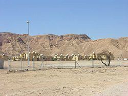
Be'er Ora (Hebrew: בְּאֵר אוֹרָה) is a communal settlement 19 kilometers north of Eilat in the far south of Israel. Located in the Arava region, just west of Highway 90, north of kibbutz Eilot, and south of Elifaz and Timna Park, it falls under the jurisdiction of Hevel Eilot Regional Council. In 2015 its population was 617.
Contents
- Site of oil spill near be er ora december 2014 environmental protection ministry spokesperson
- Map of Beer Ora Israel
- History
- Aviation
- References
Map of Be'er Ora, Israel
History
Be'er Ora was founded in 2001 as part of a program to populate the Arava and to bring people from central Israel to the Negev, which was determined to be a preferred place for new settlement. Previously there was a Gadna army base, also called Be'er Ora, in that location. The word "Be'er" means "well of water". Before the community was established, there was a well within its area that served as the first source of fresh water for Eilat, before Eilat was connected to the national water network.
The word "Ora" (light) is borrowed from the nearby Ora Mountain and Ora Creek.
Aviation
In 2004, the government decided to move Eilat Airport to an empty area near Be'er Ora. This decision was made because the airport in Eilat is located very close to residential and commercial areas (planes landing in Eilat pass directly over a large shopping mall). The new airport will be called the Ramon Airport and is due to open in 2017.