
County Manatee FIPS code 12-04350 Area 9.3 km² Zip code 34207 Area code 941 | State Florida Time zone Eastern (EST) (UTC-5) GNIS feature ID 0278252 Elevation 4 m Population 17,350 (2000) | |
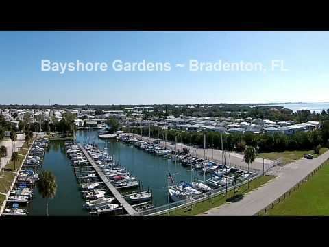 | ||
Bayshore Gardens is a census-designated place (CDP) in Manatee County, Florida, United States. The population was 17,350 at the 2000 census. It is part of the Bradenton–Sarasota–Venice Metropolitan Statistical Area.
Contents
Map of Bayshore Gardens, FL, USA
History
Bayshore Gardens was built when Sarasota was expanding northward and Bradenton was starting to expand to the south. Bayshore Gardens history had started in 1955 when three real estate developers Gus Berne, Sidney Newman and Lawrence Morton when property was being bought up from property owners. The cost of it was about $150,000,00 to $200,000,000 one of the largest commercial development in Manatee County at the time. First, came the installation of a sewage system, a water plant, laying out of roads and a drainage system. The developers intended that there should be functional beauty and utility. The roads were designed to have gentle curves for authentic reasons and to prevent traffic issues. In 1959 the Sarasota Herald-Tribune reported that "Over 600 families and almost 2,000 people inhabit Bayshore Gardens at the present time. With future growth anticipated at nearly 10,000 families..."
Geography
Bayshore Gardens is located at 27°25′59″N 82°34′39″W (27.433069, -82.577370).
According to the United States Census Bureau, the CDP has a total area of 3.6 square miles (9.3 km2), of which 3.6 square miles (9.3 km2) is land and 0.04 square miles (0.10 km2) (0.56%) is water.
Demographics
As of the census of 2000, there were 17,350 people, 8,342 households, and 4,588 families residing in the CDP. The population density was 4,874.7 people per square mile (1,881.7/km²). There were 10,121 housing units at an average density of 2,843.6/sq mi (1,097.7/km²). The racial makeup of the CDP was 89.87% White, 3.98% African American, 0.38% Native American, 1.25% Asian, 0.10% Pacific Islander, 2.34% from other races, and 2.09% from two or more races. Hispanic or Latino of any race were 8.22% of the population.
There were 8,342 households out of which 19.0% had children under the age of 18 living with them, 41.0% were married couples living together, 9.7% had a female householder with no husband present, and 45.0% were non-families. 38.2% of all households were made up of individuals and 22.5% had someone living alone who was 65 years of age or older. The average household size was 2.07 and the average family size was 2.69.
In the CDP, the population was spread out with 17.9% under the age of 18, 7.6% from 18 to 24, 25.1% from 25 to 44, 20.1% from 45 to 64, and 29.3% who were 65 years of age or older. The median age was 44 years. For every 100 females there were 87.6 males. For every 100 females age 18 and over, there were 84.6 males.
The median income for a household in the CDP was $30,159, and the median income for a family was $37,294. Males had a median income of $28,614 versus $22,656 for females. The per capita income for the CDP was $18,150. About 7.5% of families and 10.1% of the population were below the poverty line, including 15.5% of those under age 18 and 8.5% of those age 65 or over.