
Country Philippines Barangays ZIP code 8303 Province Surigao del Sur | Region Caraga (Region XIII) Time zone PST (UTC+8) Area 117.8 km² | |
 | ||
District 1st district of Surigao del Sur | ||
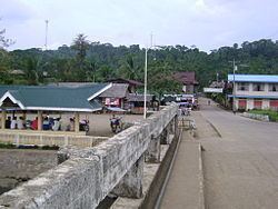
Bayabas surigao del sur philippines
Bayabas is a fifth class municipality in the province of Surigao del Sur, Philippines. According to the 2015 census, it has a population of 8,164 people.
Contents
- Bayabas surigao del sur philippines
- Map of Bayabas Surigao del Sur Philippines
- World War II
- Barangays
- References
Map of Bayabas, Surigao del Sur, Philippines
Bayabas is located between Tago and Cagwait. The Tago River separates the municipalities of Tago and Bayabas. Bayabas is consist of seven barangays mostly located in the coastlines. Though Bayabas is a small municipality, it is also abundant in natural resources especially seafoods. The town envisions to become the leading aquaculture producer in Surigao del Sur.
World War II
During 1943 and 1944 much of the east coast of Mindanao was occupied by the Japanese. Bayabas was not occupied, although at times Japanese navy ships anchored in the harbor off the coast of the town. As the Japanese occupied an increasing number of area coastal towns, refugees trickled into town. The prewar rector of San Nicolas School, in Surigao City, was one of a number of priests who sought refuge in Bayabas. Food supplies soon failed to reach town from the outside, since Japanese troops disrupted distribution.
Barangays
Bayabas is politically subdivided into 7 barangays.